IMAGES TAKEN NEAR TO
Garratt Lane, LONDON, SW17 0NW
Introduction
This page details the photographs taken nearby to Garratt Lane, SW17 0NW by members of the Geograph project.
The Geograph project started in 2005 with the aim of publishing, organising and preserving representative images for every square kilometre of Great Britain, Ireland and the Isle of Man.

There are currently over 7.5m images from over14,400 individuals and you can help contribute to the project by visiting https://www.geograph.org.uk
Image Map (Loading...)


Getting Data...Please wait
Leaflet Map data © OpenStreetMap
Images are licensed for reuse under creativecommons.org/licenses/by-sa/2.0
Notes
- Clicking on the map will re-center to the selected point.
- The higher the marker number, the further away the image location is from the centre of the postcode.
Image Listing (77 Images Found)
Images are licensed for reuse under creativecommons.org/licenses/by-sa/2.0
Image
Details
Distance
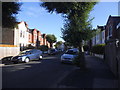
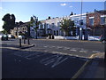
2
Garratt Lane at the corner of Keble Street
Image: © David Howard
Taken: 25 May 2014
0.03 miles
3
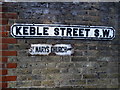
Old enamel fingerpost on Keble Street, Earlsfield
Image: © David Howard
Taken: 25 May 2014
0.03 miles
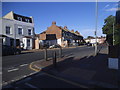
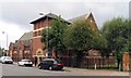
4
Garratt Lane at the junction of Keble Street
Image: © David Howard
Taken: 25 May 2014
0.03 miles
5
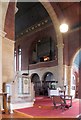
St Mary, Keble Street, Summerstown - Organ
Image: © John Salmon
Taken: 20 Aug 2006
0.03 miles
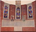
7
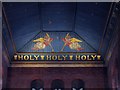
St Mary, Keble Street, Summerstown - Roof over high altar
Image: © John Salmon
Taken: 20 Aug 2006
0.03 miles
8
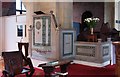
St Mary, Keble Street, Summerstown - Pulpit
Image: © John Salmon
Taken: 20 Aug 2006
0.03 miles
9
St Mary, Keble Street, Summerstown - Baptistery
Image: © John Salmon
Taken: 20 Aug 2006
0.03 miles
10
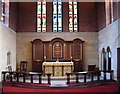
St Mary, Keble Street, Summerstown - Sanctuary
Image: © John Salmon
Taken: 20 Aug 2006
0.03 miles