IMAGES TAKEN NEAR TO
Khama Road, LONDON, SW17 0EN
Introduction
This page details the photographs taken nearby to Khama Road, SW17 0EN by members of the Geograph project.
The Geograph project started in 2005 with the aim of publishing, organising and preserving representative images for every square kilometre of Great Britain, Ireland and the Isle of Man.

There are currently over 7.5m images from over14,400 individuals and you can help contribute to the project by visiting https://www.geograph.org.uk
Image Map
Images are licensed for reuse under creativecommons.org/licenses/by-sa/2.0
Notes
- Clicking on the map will re-center to the selected point.
- The higher the marker number, the further away the image location is from the centre of the postcode.
Image Listing (63 Images Found)
Images are licensed for reuse under creativecommons.org/licenses/by-sa/2.0
Image
Details
Distance
1
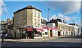
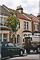
Doris Florist, Garratt Lane
A flower shop no doubt useful for visitors to the nearby St George's Hospital.
Image: © Des Blenkinsopp
Taken: 6 Feb 2025
0.07 miles
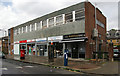
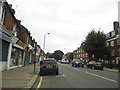
2
A Bend in Garratt Lane
The main road through a district of old terraced housing, Garratt Lane has a bit of a wobble just here.
Image: © Des Blenkinsopp
Taken: 6 Feb 2025
0.08 miles
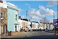
5
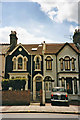
Houses in Garratt Lane, London SW17
Examples of the type of houses in Garratt Lane. Some of my ancestors lived here at one time.
Image: © Christine Matthews
Taken: 15 Jul 1999
0.12 miles
6
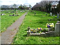
Path in Streatham Cemetery
Under the Metropolitan Burial Act of 1852, which was in response to the second cholera epidemic of 1848-49, the Streatham Burial Board acquired the land in what was then countryside. With two lodges and two mirror image chapels built in the Gothic style by William Newton-Dunn, Streatham Cemetery opened for burials in 1894. Although Streatham Cemetery is owned by the Borough of Lambeth, it is actually in Tooting in the Borough of Wandsworth. The houses on the right are in Rogers Road.
Image: © Marathon
Taken: 11 Apr 2012
0.12 miles
7
Selkirk Road, Tooting, London
Part of a terrace of houses in Selkirk Road, Tooting. Some of my ancestors lived here at one time.
Image: © Christine Matthews
Taken: 15 Jul 1999
0.12 miles
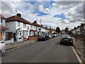
8
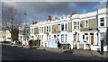
Housing Terrace, Garratt Lane
A lot of the housing nearby is of a similar age and type.
Image: © Des Blenkinsopp
Taken: 6 Feb 2025
0.13 miles
10

Old Boundary Marker by Graveney Road, Tooting, SW17
Parish Boundary Marker by the UC road, in parish of Tooting (Wandsworth District), Graveney Road, SW17, partially inset into garden wall of No 26.
Inscription reads:- : TOOTING GRAVENEY / 1882 :
Surveyed
Milestone Society National ID: SY_TOOT04pb.
Image: © Milestone Society
Taken: Unknown
0.14 miles