IMAGES TAKEN NEAR TO
SW16 9JJ
Introduction
This page details the photographs taken nearby to SW16 9JJ by members of the Geograph project.
The Geograph project started in 2005 with the aim of publishing, organising and preserving representative images for every square kilometre of Great Britain, Ireland and the Isle of Man.

There are currently over 7.5m images from over14,400 individuals and you can help contribute to the project by visiting https://www.geograph.org.uk
Image Map
Images are licensed for reuse under creativecommons.org/licenses/by-sa/2.0
Notes
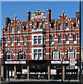
- Clicking on the map will re-center to the selected point.
- The higher the marker number, the further away the image location is from the centre of the postcode.
Image Listing (164 Images Found)
Images are licensed for reuse under creativecommons.org/licenses/by-sa/2.0
Image
Details
Distance
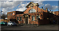
1
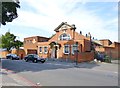
Streatham Delivery Office
On Prentis Road, off Streatham High Road; note the large Royal coat of arms.
Image: © Mike Faherty
Taken: 18 Aug 2012
0.02 miles
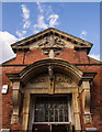
2
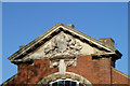
Pediment, Royal Mail delivery office
On Prentis Road, SW16.
Image: © Robin Webster
Taken: 19 Nov 2011
0.02 miles
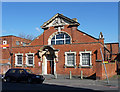
3
Royal Mail, Prentis Road, SW16
A delivery office.
Image: © Robin Webster
Taken: 19 Nov 2011
0.02 miles
4
Sorting Office, Prentis Road
In a style often labelled "Wrenaissance", even though it owes little if anything to Christopher Wren. It has a good curved porch and a pedimented gable containing the Royal Coat of Arms. It is within the Streatham High Road and Streatham Hill Conservation Area.
Information from Lambeth Council (http://www.lambeth.gov.uk/NR/exeres/CE4B5CE1-0387-40ED-B5A9-273A5160C34A.htm ).
Image: © Stephen Richards
Taken: Unknown
0.02 miles
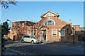
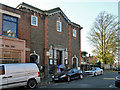
5
Royal Mail delivery office, Streatham (built c.1906)
Edwardian sorting office, with later 20th century extension.
Image: © Jim Osley
Taken: 21 Mar 2014
0.02 miles
6
Pediment and door hood, Royal Mail delivery office, Streatham
Full view of this Edwardian sorting office at Image
Image: © Jim Osley
Taken: 21 Mar 2014
0.02 miles
7
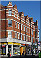
240-246 Streatham High Road
A short group between The White Lion and Prentis Road. These date from 1889 and as usual have shaped gables and stone bands. It is within the Streatham High Road and Streatham Hill Conservation Area.
The course of Streatham High Road has been a major highway between London and Sussex since Roman times. Its current appearance is largely attributable to two major spells of development. The first was during the late C19th following the opening of Streatham Hill station in 1856, and the second was after 1911 when the line to Victoria was electrified. Though much-maligned and undoubtedly blighted by heavy traffic, closer examination reveals that the road is lined with a number of interesting buildings, some of which reflect the period between the wars when Streatham was a fashionable centre of entertainment. Information from Lambeth Council (http://www.lambeth.gov.uk/NR/exeres/CE4B5CE1-0387-40ED-B5A9-273A5160C34A.htm ).
Image: © Stephen Richards
Taken: Unknown
0.03 miles
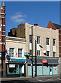
8
Liberal Synagogue, Prentis Road
Almost opposite the postal sorting office.
Image: © Robin Webster
Taken: 19 Nov 2011
0.04 miles
9
The White Lion, Streatham High Road
A fabulously elaborate Victorian pub designed by F. Gough and Co. in 1895. Stripey brick, decorated gables, a central oriel window, two octagonal chimneys and a roofline dotted with spiky finials. Although recently closed for a time, it continues as a pub under the same name, the Hobgoblin being a previous incarnation. It is within the Streatham High Road and Streatham Hill Conservation Area.
The course of Streatham High Road has been a major highway between London and Sussex since Roman times. Its current appearance is largely attributable to two major spells of development. The first was during the late C19th following the opening of Streatham Hill station in 1856, and the second was after 1911 when the line to Victoria was electrified. Though much-maligned and undoubtedly blighted by heavy traffic, closer examination reveals that the road is lined with a number of interesting buildings, some of which reflect the period between the wars when Streatham was a fashionable centre of entertainment. Information from Lambeth Council (http://www.lambeth.gov.uk/NR/exeres/CE4B5CE1-0387-40ED-B5A9-273A5160C34A.htm ).
Image: © Stephen Richards
Taken: Unknown
0.04 miles
10
226-230 Streatham High Road
No. 230 on the left dates possibly from C18th which would make it a rare survival. Stucco, with pretty little window surrounds. Its neighbour dates from the 1930s and has a cream faience facade with decorative frames round the windows. They are within the Streatham High Road and Streatham Hill Conservation Area.
The course of Streatham High Road has been a major highway between London and Sussex since Roman times. Its current appearance is largely attributable to two major spells of development. The first was during the late C19th following the opening of Streatham Hill station in 1856, and the second was after 1911 when the line to Victoria was electrified. Though much-maligned and undoubtedly blighted by heavy traffic, closer examination reveals that the road is lined with a number of interesting buildings, some of which reflect the period between the wars when Streatham was a fashionable centre of entertainment. Information from Lambeth Council (http://www.lambeth.gov.uk/NR/exeres/CE4B5CE1-0387-40ED-B5A9-273A5160C34A.htm ).
Image: © Stephen Richards
Taken: Unknown
0.04 miles