IMAGES TAKEN NEAR TO
Parklands Road, LONDON, SW16 6TF
Introduction
This page details the photographs taken nearby to Parklands Road, SW16 6TF by members of the Geograph project.
The Geograph project started in 2005 with the aim of publishing, organising and preserving representative images for every square kilometre of Great Britain, Ireland and the Isle of Man.

There are currently over 7.5m images from over14,400 individuals and you can help contribute to the project by visiting https://www.geograph.org.uk
Image Map
Images are licensed for reuse under creativecommons.org/licenses/by-sa/2.0
Notes
- Clicking on the map will re-center to the selected point.
- The higher the marker number, the further away the image location is from the centre of the postcode.
Image Listing (52 Images Found)
Images are licensed for reuse under creativecommons.org/licenses/by-sa/2.0
Image
Details
Distance
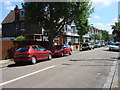
7
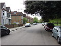
Clairview Road
Clairview Road is refreshingly free of cars which is unusual for the area
Image: © Oxyman
Taken: 24 Apr 2007
0.13 miles
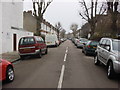
8
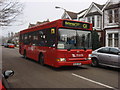
G1 bus on Clairview Road
The G1 bus route is a local route running from Clapham Junction to Norbury and operated by Travel London for London Buses. At this point Passengers can hail it wherever it is convenient as opposed to being required to wait at a bus stop.
Image: © Oxyman
Taken: 14 Jan 2009
0.13 miles