IMAGES TAKEN NEAR TO
Blegborough Road, LONDON, SW16 6DL
Introduction
This page details the photographs taken nearby to Blegborough Road, SW16 6DL by members of the Geograph project.
The Geograph project started in 2005 with the aim of publishing, organising and preserving representative images for every square kilometre of Great Britain, Ireland and the Isle of Man.

There are currently over 7.5m images from over14,400 individuals and you can help contribute to the project by visiting https://www.geograph.org.uk
Image Map
Images are licensed for reuse under creativecommons.org/licenses/by-sa/2.0
Notes
- Clicking on the map will re-center to the selected point.
- The higher the marker number, the further away the image location is from the centre of the postcode.
Image Listing (110 Images Found)
Images are licensed for reuse under creativecommons.org/licenses/by-sa/2.0
Image
Details
Distance
1
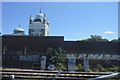
Streatham Water Works
Great piece of Victorian craziness. This Grade II listed building houses some monitoring equipment for the Southern Water London Water Ring. The legend on the front reads "Southwark & Vauxhall Water Company".
Image: © Martyn Davies
Taken: 27 Apr 2006
0.09 miles
5
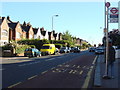
Thrale Road Bus stop
Located on Mitcham Lane for buses towards Streatham
Image: © Oxyman
Taken: 29 May 2009
0.10 miles
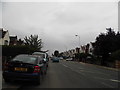
6
Mitcham Lane, SW16
Near the junction of Blegborough Road.
Image: © Danny P Robinson
Taken: 26 Nov 2006
0.11 miles
7
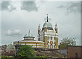
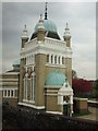
Streatham Waterworks Pumping Station
An elaborate design for a functional building. It was built near the end of the nineteenth century.
Image: © John Allan
Taken: 16 Aug 2012
0.12 miles
8
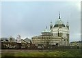
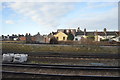
Streatham waterworks seen from the railway
In the foreground, tracks climbing up to cross the London-Brighton main line a little to the right of this photograph, after which they head south via Hackbridge to Sutton.
Image: © Christopher Hilton
Taken: 17 Jan 2014
0.12 miles
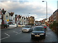
9
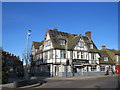
The Furzedown pub, Streatham
The Furzedown pub in Streatham, in the suburbs of south London. The road passing in front of the pub forms part of the route of the short A216 road.
This image was taken on a bright and sunny January day. The sun was low in the sky, casting long shadows.
Image: © Malc McDonald
Taken: 4 Jan 2020
0.12 miles