IMAGES TAKEN NEAR TO
Streatham High Road, LONDON, SW16 6AU
Introduction
This page details the photographs taken nearby to Streatham High Road, SW16 6AU by members of the Geograph project.
The Geograph project started in 2005 with the aim of publishing, organising and preserving representative images for every square kilometre of Great Britain, Ireland and the Isle of Man.

There are currently over 7.5m images from over14,400 individuals and you can help contribute to the project by visiting https://www.geograph.org.uk
Image Map
Images are licensed for reuse under creativecommons.org/licenses/by-sa/2.0
Notes
- Clicking on the map will re-center to the selected point.
- The higher the marker number, the further away the image location is from the centre of the postcode.
Image Listing (143 Images Found)
Images are licensed for reuse under creativecommons.org/licenses/by-sa/2.0
Image
Details
Distance
1
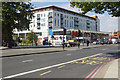
Streatham High Road
This stretch of Streatham High Road is dominated by the Tesco Extra.
Image: © Stephen McKay
Taken: 6 Sep 2018
0.04 miles
2
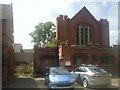
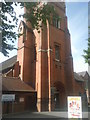
The derelict church hall of Streatham United Reformed Church
The church was consecrated in 1901 as the Congregational Church and designed by James Cubitt. It became the United Reformed Church in 1972. It is Grade II listed. Its tower is a striking feature along Streatham High Road. The hall was built in 1912 and at the time of taking this photograph was derelict. It was demolished at the end of 2011 as part of the Streatham Hub development.
Image: © Marathon
Taken: 3 Sep 2010
0.04 miles
4
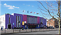
Tesco Extra, Streatham
The huge store appears to form the ground and first floors of a block of flats. To its right is the bus station Image The amount of traffic may relate to this being the last Saturday of the school summer holidays. Streatham High Road is the A23; are they all coming back from Brighton?
Photo number 7590252.
Image: © Robin Stott
Taken: 2 Sep 2023
0.05 miles
5
Streatham United Reformed Church
The church was consecrated in 1901 as the Congregational Church and designed by James Cubitt. It became the United Reformed Church in 1972. It is Grade II listed. Its tower is a striking feature along Streatham High Road.
Image: © Marathon
Taken: 3 Sep 2010
0.05 miles
6
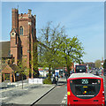
Streatham High Road by United Reformed Church
The church is a grade II listed building of 1900.
Image: © Robin Webster
Taken: 19 Apr 2019
0.05 miles
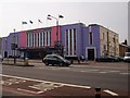
7
Ice Rink, Streatham High Road
A fine building which immediately evokes the 1930s (the current colour scheme is fairly recent). Long and low in a "moderne" style, its horizontality counterbalanced by tall, narrow windows. At the ends are Art Deco doorways below keystoned windows. The architect was Robert Cromie who usually specialised in cinemas. The rink itself covers 21,000 sq ft, enough for 1,000 skaters. They'll have to find somewhere else to go for a time as the ice rink is scheduled for demolition as part of the Streatham Hub development. It is within the Streatham High Road and Streatham Hill Conservation Area.
The course of Streatham High Road has been a major highway between London and Sussex since Roman times. Its current appearance is largely attributable to two major spells of development. The first was during the late C19th following the opening of Streatham Hill station in 1856, and the second was after 1911 when the line to Victoria was electrified. Though much-maligned and undoubtedly blighted by heavy traffic, closer examination reveals that the road is lined with a number of interesting buildings, some of which reflect the period between the wars when Streatham was a fashionable centre of entertainment. Information from Lambeth Council (http://www.lambeth.gov.uk/NR/exeres/CE4B5CE1-0387-40ED-B5A9-273A5160C34A.htm ).
Update: demolished in late 2011.
Image: © Stephen Richards
Taken: Unknown
0.05 miles
8

Streatham Regeneration Project, Streatham High Road (2)
The site has been cleared and work is well underway on this development which has been mired in debate for several years and caused considerable local angst, and, to be fair, anticipation. The placards indicate that it will include a leisure centre (including swimming pools, sports hall, fitness suites and ice rink), 250 new homes, 60,000 square feet of retail "offering" (eh?), parking for up to 540 vehicles, and, the crowning glory, a new bus turnaround facility. The sign is rather coy about the financial involvement of Tesco, which will be availing itself of a considerable chunk of that retail "offering". The main construction company is Vinci. Lambeth Council expect construction "to be completed towards the end of 2013".
What has been demolished so that all this may arise is everything on the west side of the High Road between Natal Road and Streatham Station except the small block immediately south of the station, the United Reformed Church and (oddly) the couple of shops on the corner of Natal Road. So, the left-hand bit of this Image], this Image], this Image] and this Image] have all gone. A temporary ice rink is available in Brixton. View from the south: Image
Image: © Stephen Richards
Taken: 30 Jul 2012
0.05 miles
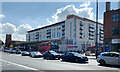
9

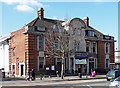
Streatham Bus Station
The destination referred to on the bus as Streatham Station is Streatham rail station, a few steps along Streatham High Road. The building on the left near the camera is a Tesco Extra store.
Photo number 7589256.
Image: © Robin Stott
Taken: 2 Sep 2023
0.05 miles
10
Swimming Pool, Streatham High Road
Designed by Wandsworth's Borough Architect, Ernest Elford, in a style typical of Edwardian civic architecture. Basically classical - symmetrical, brick, quoins - with some mildly idiosyncratic detailing. Construction was completed in 1927. The pool is scheduled for demolition as part of the Streatham Hub development. It is within the Streatham High Road and Streatham Hill Conservation Area.
The course of Streatham High Road has been a major highway between London and Sussex since Roman times. Its current appearance is largely attributable to two major spells of development. The first was during the late C19th following the opening of Streatham Hill station in 1856, and the second was after 1911 when the line to Victoria was electrified. Though much-maligned and undoubtedly blighted by heavy traffic, closer examination reveals that the road is lined with a number of interesting buildings, some of which reflect the period between the wars when Streatham was a fashionable centre of entertainment. Information from Lambeth Council (http://www.lambeth.gov.uk/NR/exeres/CE4B5CE1-0387-40ED-B5A9-273A5160C34A.htm ).
Update: demolished in late 2011.
Image: © Stephen Richards
Taken: Unknown
0.06 miles