IMAGES TAKEN NEAR TO
Woodmansterne Road, LONDON, SW16 5UQ
Introduction
This page details the photographs taken nearby to Woodmansterne Road, SW16 5UQ by members of the Geograph project.
The Geograph project started in 2005 with the aim of publishing, organising and preserving representative images for every square kilometre of Great Britain, Ireland and the Isle of Man.

There are currently over 7.5m images from over14,400 individuals and you can help contribute to the project by visiting https://www.geograph.org.uk
Image Map
Images are licensed for reuse under creativecommons.org/licenses/by-sa/2.0
Notes
- Clicking on the map will re-center to the selected point.
- The higher the marker number, the further away the image location is from the centre of the postcode.
Image Listing (7 Images Found)
Images are licensed for reuse under creativecommons.org/licenses/by-sa/2.0
Image
Details
Distance
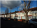
2
Glenister Park Road Junction with Sherwood Avenue
Image: © James Emmans
Taken: 17 Feb 2017
0.18 miles
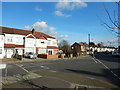
4
Helmsdale Road, Streatham
Helmsdale Road is a residential road in Streatham, in the suburbs of south London.
This image was taken on a January day. The sun was low in the sky, shadows were long and trees were bare.
Image: © Malc McDonald
Taken: 11 Jan 2020
0.20 miles
5
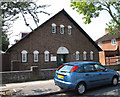
Holy Redeemer parish hall
The hall, dating from 1927, is adjacent to the vicarage Image
Image: © Stephen Craven
Taken: 10 Aug 2012
0.22 miles
6
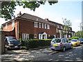
Holy Redeemer vicarage
The vicarage is next to the church Image
Image: © Stephen Craven
Taken: 10 Aug 2012
0.23 miles
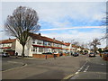
7
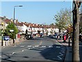
Streatham Vale
Most of this area was developed during the decade after 1922. The pebble-dashing firm at the bottom of the road must do very good business.
Image: © Stephen Richards
Taken: Unknown
0.24 miles