IMAGES TAKEN NEAR TO
Juniper Gardens, LONDON, SW16 5TJ
Introduction
This page details the photographs taken nearby to Juniper Gardens, SW16 5TJ by members of the Geograph project.
The Geograph project started in 2005 with the aim of publishing, organising and preserving representative images for every square kilometre of Great Britain, Ireland and the Isle of Man.

There are currently over 7.5m images from over14,400 individuals and you can help contribute to the project by visiting https://www.geograph.org.uk
Image Map
Images are licensed for reuse under creativecommons.org/licenses/by-sa/2.0
Notes
- Clicking on the map will re-center to the selected point.
- The higher the marker number, the further away the image location is from the centre of the postcode.
Image Listing (20 Images Found)
Images are licensed for reuse under creativecommons.org/licenses/by-sa/2.0
Image
Details
Distance
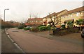
1
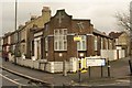
Streatham Vale Baptist Church
The church occupies the corner between Leonard Road (left) and Juniper Gardens, a cul-de-sac.
Image: © Derek Harper
Taken: 13 Jan 2011
0.02 miles
2
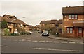
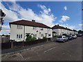
Veronica Gardens, Mitcham
A winding residential cul-de-sac seen from across Meopham Road.
Image: © Derek Harper
Taken: 13 Jan 2011
0.09 miles
3
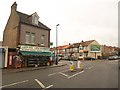
Leonard Road, Mitcham
A view in the other direction from the same spot as Image, with Leonard Road bending left at the junction with Abercairn Road (right) after passing the Leonard Mini Market.
Image: © Derek Harper
Taken: 13 Jan 2011
0.11 miles
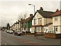
4
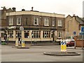
The Mitcham Mint
The pub name recalls the fact that Mitcham was famous for cultivating mint for two centuries from the mid-C18. Seen here across a roundabout where the B272 bends east at the southern end of Streatham Vale.
Image: © Derek Harper
Taken: 13 Jan 2011
0.12 miles
5
Bennetts Close, Mitcham
These modern houses near Streatham Vale Park face Oakleigh Way Recreation Ground.
Image: © Derek Harper
Taken: 13 Jan 2011
0.13 miles
6
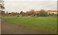
Oakleigh Way Recreation Ground
From the Oakleigh Way entrance, showing the children's playground. The houses on the right appear in Image
Image: © Derek Harper
Taken: 13 Jan 2011
0.14 miles
7
Grove Road, Mitcham
Houses along the north side of the road, seen from the junction with Eldertree Way.
Image: © Derek Harper
Taken: 13 Jan 2011
0.15 miles
8
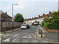
Rowan Crescent, near Streatham
Rowan Crescent is a residential road in the suburbs of south London.
Image: © Malc McDonald
Taken: 11 Jan 2020
0.17 miles
10
The Mausoleum or Glade Gardens, Streatham Park Cemetery
Streatham Park Cemetery opened as the Great Southern Cemetery in 1909. Up to the Second World War Streatham Park Cemetery accounted for one fifth of all burials in South London. It is a strange mixture with colourful gardens of remembrance near the entrance in Rowan Road, large mausolea just inside the entrance and a 'street' of even larger mausolea, many to Italians, beyond the war memorial as seen here. The 'street' has a sign at its entrance saying "The Mausoleum" and "Glade Gardens".
A more complete history is given at http://www.londongardensonline.org.uk/gardens-online-record.asp?ID=MER056
Image: © Marathon
Taken: 1 Mar 2017
0.19 miles