IMAGES TAKEN NEAR TO
Barrow Road, LONDON, SW16 5PE
Introduction
This page details the photographs taken nearby to Barrow Road, SW16 5PE by members of the Geograph project.
The Geograph project started in 2005 with the aim of publishing, organising and preserving representative images for every square kilometre of Great Britain, Ireland and the Isle of Man.

There are currently over 7.5m images from over14,400 individuals and you can help contribute to the project by visiting https://www.geograph.org.uk
Image Map
Images are licensed for reuse under creativecommons.org/licenses/by-sa/2.0
Notes
- Clicking on the map will re-center to the selected point.
- The higher the marker number, the further away the image location is from the centre of the postcode.
Image Listing (157 Images Found)
Images are licensed for reuse under creativecommons.org/licenses/by-sa/2.0
Image
Details
Distance
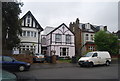
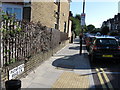
2
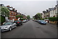
Large Victorian / Edwardian houses, Lewin Rd
Image: © N Chadwick
Taken: 8 May 2010
0.05 miles
4
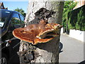
Bracket Fungus, Lewin Road, Streatham
Image: © Alex McGregor
Taken: 18 Aug 2010
0.06 miles
5
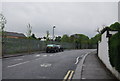
The middle of Lewin Rd
The route of the Capital Ring.
Image: © N Chadwick
Taken: 8 May 2010
0.06 miles
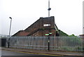
7
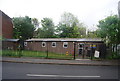
Streatham Common Scout troop, Scout Hut, Estreham Rd
Image: © N Chadwick
Taken: 8 May 2010
0.08 miles
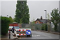
9
Footbridge across the railway line, Estreham Rd
Note the Capital Ring signpost.
Image: © N Chadwick
Taken: 8 May 2010
0.09 miles