IMAGES TAKEN NEAR TO
Penistone Road, LONDON, SW16 5LU
Introduction
This page details the photographs taken nearby to Penistone Road, SW16 5LU by members of the Geograph project.
The Geograph project started in 2005 with the aim of publishing, organising and preserving representative images for every square kilometre of Great Britain, Ireland and the Isle of Man.

There are currently over 7.5m images from over14,400 individuals and you can help contribute to the project by visiting https://www.geograph.org.uk
Image Map
Images are licensed for reuse under creativecommons.org/licenses/by-sa/2.0
Notes
- Clicking on the map will re-center to the selected point.
- The higher the marker number, the further away the image location is from the centre of the postcode.
Image Listing (47 Images Found)
Images are licensed for reuse under creativecommons.org/licenses/by-sa/2.0
Image
Details
Distance
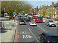
1
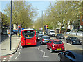
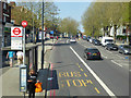
A23, Streatham High Road, SW16
Heading north.
Image: © Robin Webster
Taken: 19 Apr 2019
0.06 miles
2
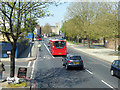
A23, Streatham High Road, SW16
Heading north.
Image: © Robin Webster
Taken: 19 Apr 2019
0.08 miles
3
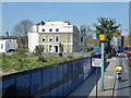
Pair of large houses on Streatham High Road, SW16
Probably flats now.
Image: © Robin Webster
Taken: 19 Apr 2019
0.08 miles
4
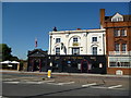
The 'Pied Bull': Streatham High Road
Another black-painted pub. Ready for its own funeral?
Image: © Dr Neil Clifton
Taken: 24 Jul 2012
0.08 miles
5
A23, Streatham High Road, SW16
At the Arragon Gardens bus stop, towards Streatham Hill or Tooting.
Image: © Robin Webster
Taken: 19 Apr 2019
0.09 miles
6
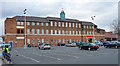
Former silk mill, Streatham High Road
A London rarity. A former silk mill, complete with cupola, built c1820 by "a manufacturer, Stephen Wilson, in an attempt to convert the Spitalfields silk-weaving industry to the factory system." The mill's buildings were subsumed into P.B. Cow's India Rubber Works (as in Cow Gum) early in the C20th. Much of the site was demolished in 1989 prior to conversion to a supermarket (by David Gibson Architects). Grade II listed. It is within the Streatham Common Conservation Area.
Now Sainsbury's.
Image: © Stephen Richards
Taken: Unknown
0.10 miles
7
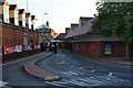
The entrance to Sainsbury's, Streatham
Running straight off Streatham High Road.
Image: © Bill Boaden
Taken: 2 Aug 2014
0.13 miles
8
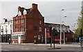
Former Beehive Tavern, Streatham High Road
Built as a coffee house and working men's lodgings in 1878-79 to the designs of Ernest George and Harold Peto. George lived in Streatham for some years and designed several buildings in the area. Note the Queen Anne-style white-painted sash windows, the pargetted dormers, and the pronounced chimney. (The ground floor projection is C20th.) Grade II listed. It is within the Streatham Common Conservation Area.
It is now used as solicitors' offices and a day nursery. The C19th inn next door, the Pied Bull, has one less rival to worry about, a situation lent piquancy by virtue of the coffee house originally being built by the temperance movement to entice people away from alcohol.
Image: © Stephen Richards
Taken: Unknown
0.14 miles
9
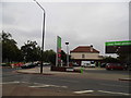
Petrol station on Streatham High Road
On the corner of Streatham Common South
Image: © David Howard
Taken: 29 Sep 2013
0.14 miles
10
A23, Streatham High Road, SW16
Heading north.
Image: © Robin Webster
Taken: 19 Apr 2019
0.16 miles