IMAGES TAKEN NEAR TO
Hassocks Road, LONDON, SW16 5EX
Introduction
This page details the photographs taken nearby to Hassocks Road, SW16 5EX by members of the Geograph project.
The Geograph project started in 2005 with the aim of publishing, organising and preserving representative images for every square kilometre of Great Britain, Ireland and the Isle of Man.

There are currently over 7.5m images from over14,400 individuals and you can help contribute to the project by visiting https://www.geograph.org.uk
Image Map
Images are licensed for reuse under creativecommons.org/licenses/by-sa/2.0
Notes
- Clicking on the map will re-center to the selected point.
- The higher the marker number, the further away the image location is from the centre of the postcode.
Image Listing (12 Images Found)
Images are licensed for reuse under creativecommons.org/licenses/by-sa/2.0
Image
Details
Distance
1
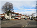
Helmsdale Road, Streatham
Helmsdale Road is a residential road in Streatham, in the suburbs of south London.
This image was taken on a January day. The sun was low in the sky, shadows were long and trees were bare.
Image: © Malc McDonald
Taken: 11 Jan 2020
0.08 miles
2
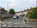
Rowan Crescent, near Streatham
Rowan Crescent is a residential road in the suburbs of south London.
Image: © Malc McDonald
Taken: 11 Jan 2020
0.08 miles
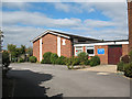
3
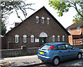
Holy Redeemer parish hall
The hall, dating from 1927, is adjacent to the vicarage Image
Image: © Stephen Craven
Taken: 10 Aug 2012
0.17 miles
4
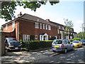
Holy Redeemer vicarage
The vicarage is next to the church Image
Image: © Stephen Craven
Taken: 10 Aug 2012
0.18 miles
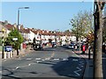
5
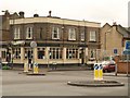
The Mitcham Mint
The pub name recalls the fact that Mitcham was famous for cultivating mint for two centuries from the mid-C18. Seen here across a roundabout where the B272 bends east at the southern end of Streatham Vale.
Image: © Derek Harper
Taken: 13 Jan 2011
0.18 miles
6
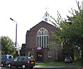
Holy Redeemer church, Streatham Vale
This Anglican church by architect Martin Travers is on the corner of Streatham Vale (foreground) and Churchmore Road.
Image: © Stephen Craven
Taken: 10 Aug 2012
0.19 miles
7
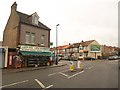
Leonard Road, Mitcham
A view in the other direction from the same spot as Image, with Leonard Road bending left at the junction with Abercairn Road (right) after passing the Leonard Mini Market.
Image: © Derek Harper
Taken: 13 Jan 2011
0.22 miles
8
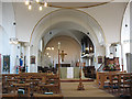
St Olave's church, Mitcham: interior
A total contrast to the almost industrial exterior Image, the interior is in "Byzantine" style, with a large reinforced concrete central dome over the crossing. The eighteenth-century pulpit seen here (and other fittings) came from the closed church of St. Olaf in Southwark. (source: http://www.southwark.anglican.org/parishes/171j )
Image: © Stephen Craven
Taken: 22 Sep 2009
0.24 miles
9
St Olave's church hall, Mitcham
The hall is adjacent to the church Image and used by a nursery.
Image: © Stephen Craven
Taken: 22 Sep 2009
0.24 miles
10
Streatham Vale
Most of this area was developed during the decade after 1922. The pebble-dashing firm at the bottom of the road must do very good business.
Image: © Stephen Richards
Taken: Unknown
0.24 miles