IMAGES TAKEN NEAR TO
Pollards Hill South, LONDON, SW16 4ND
Introduction
This page details the photographs taken nearby to Pollards Hill South, SW16 4ND by members of the Geograph project.
The Geograph project started in 2005 with the aim of publishing, organising and preserving representative images for every square kilometre of Great Britain, Ireland and the Isle of Man.

There are currently over 7.5m images from over14,400 individuals and you can help contribute to the project by visiting https://www.geograph.org.uk
Image Map
Images are licensed for reuse under creativecommons.org/licenses/by-sa/2.0
Notes
- Clicking on the map will re-center to the selected point.
- The higher the marker number, the further away the image location is from the centre of the postcode.
Image Listing (88 Images Found)
Images are licensed for reuse under creativecommons.org/licenses/by-sa/2.0
Image
Details
Distance
1
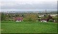
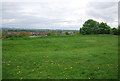
View south-east from Pollards Hill
A view towards the Thornton Heath area, with little of note in view.
Image: © Robin Webster
Taken: 1 Jul 2011
0.01 miles
3
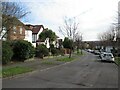
Pollards Hill West, Norbury
Pollards Hill West is a residential road in Norbury, in the south London suburbs.
This image was taken on a February afternoon. Trees were bare for the winter season.
Image: © Malc McDonald
Taken: 19 Feb 2023
0.07 miles
6
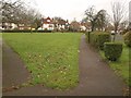
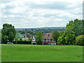
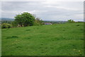
Green, Pollards Hill
A triangular green created among the curving roads of the estate. This view is from the southern corner by Pollards Hill South.
Image: © Derek Harper
Taken: 13 Jan 2011
0.10 miles
9
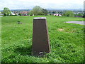
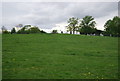
Trig point on Pollards Hill
Pollards Hill occupies the highest point in Norbury and on a clear day the view stretches to Windsor Castle. It was originally part of the Great North Wood and the name 'Pollard' derives from this connection. The road layout of Pollards Hill was shown on maps of 1868 with two avenues of trees. Pollards Hill had been left as an open space as the surrounding estate developed and it was given to Croydon Council in 1913 by Sir Frederick Ederidge. A pedestal was erected on the summit of the hill to show the direction of various local landmarks but the direction pointer on the top has disappeared. The trig point seen here is close by. The view takes in the twin chimneys of the former Waddon Marsh Power Station, now next to IKEA, on the right. Croydon town centre is in the centre of the photograph, just to the right of the trees.
Image: © Marathon
Taken: 6 Jun 2012
0.10 miles
10
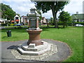
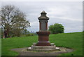
Drinking fountain at Pollards Hill
Pollards Hill occupies the highest point in Norbury and on a clear day the view stretches to Windsor Castle. It was originally part of the Great North Wood and the name 'Pollard' derives from this connection. The road layout of Pollards Hill was shown on maps of 1868 with two avenues of trees. Pollards Hill had been left as an open space as the surrounding estate developed and it was given to Croydon Council in 1913 by Sir Frederick Ederidge. This drinking fountain, which no longer works, is towards the bottom of the park. The houses beyond, leading down the hill, are in Pollards Hill West.
Image: © Marathon
Taken: 6 Jun 2012
0.10 miles