IMAGES TAKEN NEAR TO
Streatham Common North, LONDON, SW16 3HP
Introduction
This page details the photographs taken nearby to Streatham Common North, SW16 3HP by members of the Geograph project.
The Geograph project started in 2005 with the aim of publishing, organising and preserving representative images for every square kilometre of Great Britain, Ireland and the Isle of Man.

There are currently over 7.5m images from over14,400 individuals and you can help contribute to the project by visiting https://www.geograph.org.uk
Image Map
Images are licensed for reuse under creativecommons.org/licenses/by-sa/2.0
Notes
- Clicking on the map will re-center to the selected point.
- The higher the marker number, the further away the image location is from the centre of the postcode.
Image Listing (125 Images Found)
Images are licensed for reuse under creativecommons.org/licenses/by-sa/2.0
Image
Details
Distance
1
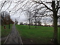
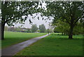
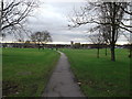
Path in Streatham Common (2)
A path leads from Streatham Common North (road), up through the common towards Streatham Common South (road).
Image: © David Anstiss
Taken: 18 Dec 2011
0.07 miles
2
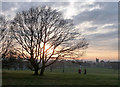
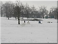
Wintry Streatham Common (6)
After a day largely blanketed by cloud, the sun sets vividly behind a youngish oak. The common unfurls down the slope until it meets Streatham High Road, on which can be seen the tower of Immanuel church (Image).
Streatham Common comprises a large expanse of open grassland sloping up from Streatham High Road in the west, to woodland and the Rookery in the east. The latter opened in 1913 and is a more formal garden originally in the grounds of the eponymous house. It includes the site of Streatham Spa which made Streatham fashionable for a time in the early-mid C18th. The early history of the common is murky, but it stretches back to the Norman Conquest, and the Domesday Book recorded a Lime Common which stretched from Norbury to Tulse Hill. Following 500 years of church ownership its status as a public space was ensured by an Act of Parliament when it was taken over by the Metropolitan Board of Works in 1883. After several further transferrals, ownership passed to Lambeth Council in 1971. Information from Lambeth Council (http://www.lambeth.gov.uk/NR/exeres/CE4B5CE1-0387-40ED-B5A9-273A5160C34A.htm ).
Image: © Stephen Richards
Taken: 12 Dec 2012
0.07 miles
5
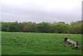
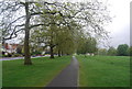
Path in Streatham Common
A path leads from Streatham Common North (road), through the common towards Streatham High Road.
Image is in the background.
Image: © David Anstiss
Taken: 18 Dec 2011
0.10 miles
9
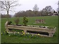
Cattle Trough, Streatham Common
Cattle Trough at the top of Streatham Common, marked "METROPOLITAN DRINKING FOUNTAIN & CATTLE TROUGH ASSOCIATION"
Image: © Nicky Johns
Taken: 16 Apr 2006
0.11 miles
10
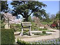
Rookery Well, Streatham
Well in The Rookery, Streatham Common. One of three original wells of Streatham Spa water dating from 1659.
Image: © Nicky Johns
Taken: 22 Apr 2006
0.11 miles