IMAGES TAKEN NEAR TO
Heybridge Avenue, LONDON, SW16 3DX
Introduction
This page details the photographs taken nearby to Heybridge Avenue, SW16 3DX by members of the Geograph project.
The Geograph project started in 2005 with the aim of publishing, organising and preserving representative images for every square kilometre of Great Britain, Ireland and the Isle of Man.

There are currently over 7.5m images from over14,400 individuals and you can help contribute to the project by visiting https://www.geograph.org.uk
Image Map
Images are licensed for reuse under creativecommons.org/licenses/by-sa/2.0
Notes
- Clicking on the map will re-center to the selected point.
- The higher the marker number, the further away the image location is from the centre of the postcode.
Image Listing (43 Images Found)
Images are licensed for reuse under creativecommons.org/licenses/by-sa/2.0
Image
Details
Distance
1
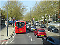
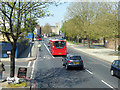
A23, Streatham High Road, SW16
Heading north.
Image: © Robin Webster
Taken: 19 Apr 2019
0.10 miles
2
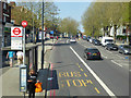
A23, Streatham High Road, SW16
At the Arragon Gardens bus stop, towards Streatham Hill or Tooting.
Image: © Robin Webster
Taken: 19 Apr 2019
0.10 miles
4
A23, Streatham High Road, SW16
Heading north.
Image: © Robin Webster
Taken: 19 Apr 2019
0.14 miles
5
A23, Streatham High Road, SW16
Heading north.
Image: © Robin Webster
Taken: 19 Apr 2019
0.14 miles
6
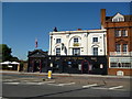
The 'Pied Bull': Streatham High Road
Another black-painted pub. Ready for its own funeral?
Image: © Dr Neil Clifton
Taken: 24 Jul 2012
0.16 miles
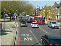
7
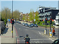
A23, Streatham High Road, SW16
At the Green Lane traffic lights, heading north.
Image: © Robin Webster
Taken: 19 Apr 2019
0.16 miles
8
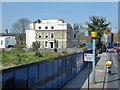
Pair of large houses on Streatham High Road, SW16
Probably flats now.
Image: © Robin Webster
Taken: 19 Apr 2019
0.16 miles
9

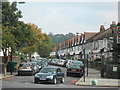
9 and 10 Streatham Common South
To find one C18th house in this area might be considered fortunate, to find two might be considered auspicious, but to find two next to each other is nothing short of miraculous. Their foundations are shown on Rocque's map of 1746.
No. 9, on the right, has arched windows on the ground floor and, according to the listing details, a gambrel roof although it looks hipped to me. Grade II listed.
No. 10, known as Ripley House, may have been built by the architect Thomas Ripley for himself, but I can find no evidence to support this claim. It was an ale house in 1738, the cellar of which still exists.
Information partly from Lambeth Council. Both are within the Streatham Common Conservation Area.
Image: © Stephen Richards
Taken: Unknown
0.17 miles
10
Lewis & Co Ltd, Builders Merchant, Streatham Common South
Image: © N Chadwick
Taken: 8 May 2010
0.18 miles