IMAGES TAKEN NEAR TO
Covington Way, LONDON, SW16 3AQ
Introduction
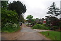
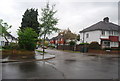
This page details the photographs taken nearby to Covington Way, SW16 3AQ by members of the Geograph project.
The Geograph project started in 2005 with the aim of publishing, organising and preserving representative images for every square kilometre of Great Britain, Ireland and the Isle of Man.

There are currently over 7.5m images from over14,400 individuals and you can help contribute to the project by visiting https://www.geograph.org.uk
Image Map
Images are licensed for reuse under creativecommons.org/licenses/by-sa/2.0
Notes
- Clicking on the map will re-center to the selected point.
- The higher the marker number, the further away the image location is from the centre of the postcode.
Image Listing (111 Images Found)
Images are licensed for reuse under creativecommons.org/licenses/by-sa/2.0
Image
Details
Distance
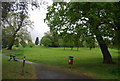
2
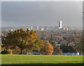
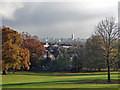
Autumnal park, Norwood Grove (8)
View south-east across the roofs of Norbury and Thornton Heath towards Croydon's towering skyline. The unfortunate recent steroidal (and Carbuncle Cup-nominated) addition on the right is its new tallest building, the Tower at Berkeley Homes's Saffron Square development. Here, the sharp winter sunshine has bleached it of its virulent colour, which renders it slightly more palatable, as does the distance between viewer and subject.
The house and its park were bought by Croydon Corporation in 1926. The park covers some 32 acres and is on English Heritage's Register of Parks and Gardens of Special Historic Interest.
Image: © Stephen Richards
Taken: 22 Nov 2016
0.04 miles
3
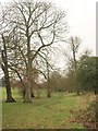
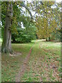
Norwood Grove
A view along the eastern edge of the park from the point where the Capital Ring enters from Covington Grove.
Image: © Derek Harper
Taken: 13 Jan 2011
0.04 miles
4
Capital Ring running through Norwood Grove
Image: © N Chadwick
Taken: 8 May 2010
0.05 miles
5
Autumnal park, Norwood Grove (9)
Looking south-east towards Croydon's towering skyline. The unfortunate recent steroidal (and Carbuncle Cup-nominated) addition roughly central is its new tallest building, the Tower at Berkeley Homes's Saffron Square development. Here, the sharp winter sunshine has bleached it of its virulent colour, which renders it slightly more palatable, as does the distance between viewer and subject.
The house and its park were bought by Croydon Corporation in 1926. The park covers some 32 acres and is on English Heritage's Register of Parks and Gardens of Special Historic Interest.
Image: © Stephen Richards
Taken: 22 Nov 2016
0.06 miles
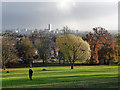
7
Central Croydon from Norwood Grove
Until 1635, Norwood Grove formed part of the Great Streatham Common, which was referred to in the Domesday Book as Lime Common and stretched from Norbury to Tulse Hill. In that year what is now Norwood Grove became a shooting estate with a lodge for the 5th Duke of Portland. The present mansion was built in the mid 19th century, and soon after it became the residence of Mr. Arthur Anderson, MP, one of the founders of the Peninsular and Oriental Steamship line - the P. & O. After the death of Anderson in 1862, the mansion became the property of the Nettlefold family, the screw manufacturers which became part of Guest, Keen and Nettlefold. The Nettlefolds left in 1913. After the 1914-18 war, the local residents launched a fighting fund to save Norwood Grove from building development and the open space was dedicated for ever to the use of the public by the Prince of Wales at a gala opening in November 1926. The top of Norwood Grove near the house is 300 feet above sea level and gives very wide views to the south and west towards the North Downs and Windsor Castle.
In this direction the office blocks in the centre of Croydon look close while beyond and to the left are the wooded heights of Croham Hurst and Addington Hills.
Image: © Marathon
Taken: 3 Jul 2013
0.06 miles
8
Autumnal park, Norwood Grove (10)
View south-east across the roofs of Norbury and Thornton Heath towards Croydon's towering skyline. The unfortunate recent steroidal (and Carbuncle Cup-nominated) addition on the right is its new tallest building, the Tower at Berkeley Homes's Saffron Square development. Here, the sharp winter sunshine has bleached it of its virulent colour, which renders it slightly more palatable, as does the distance between viewer and subject.
The house and its park were bought by Croydon Corporation in 1926. The park covers some 32 acres and is on English Heritage's Register of Parks and Gardens of Special Historic Interest.
Image: © Stephen Richards
Taken: 22 Nov 2016
0.06 miles
9
Norwood Grove
Until 1635, Norwood Grove formed part of the Great Streatham Common, which was referred to in the Domesday Book as Lime Common and stretched from Norbury to Tulse Hill. In that year what is now Norwood Grove became a shooting estate with a lodge for the 5th Duke of Portland. The present mansion was built in the mid 19th century, and soon after it became the residence of Mr. Arthur Anderson, MP, one of the founders of the Peninsular and Oriental Steamship line - the P. & O. After the death of Anderson in 1862, the mansion became the property of the Nettlefold family, the screw manufacturers which became part of Guest, Keen and Nettlefold. The Nettlefolds left in 1913. After the 1914-18 war, the local residents launched a fighting fund to save Norwood Grove from building development and the open space was dedicated for ever to the use of the public by the Prince of Wales at a gala opening in November 1926. The top of Norwood Grove near the house is 300 feet above sea level and gives very wide views to the south and west towards the North Downs and Windsor Castle.
Image: © Marathon
Taken: 31 Aug 2011
0.07 miles