IMAGES TAKEN NEAR TO
Sunnyhill Road, LONDON, SW16 2UG
Introduction
This page details the photographs taken nearby to Sunnyhill Road, SW16 2UG by members of the Geograph project.
The Geograph project started in 2005 with the aim of publishing, organising and preserving representative images for every square kilometre of Great Britain, Ireland and the Isle of Man.

There are currently over 7.5m images from over14,400 individuals and you can help contribute to the project by visiting https://www.geograph.org.uk
Image Map
Images are licensed for reuse under creativecommons.org/licenses/by-sa/2.0
Notes
- Clicking on the map will re-center to the selected point.
- The higher the marker number, the further away the image location is from the centre of the postcode.
Image Listing (133 Images Found)
Images are licensed for reuse under creativecommons.org/licenses/by-sa/2.0
Image
Details
Distance
1
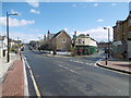
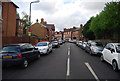
Sunnyhill Road, Streatham
This view looks along Sunnyhill Road with Wellfield Road leading off to the right past the Leigham Arms. The Standard describes the Leigham Arms thus: "A country pub somehow dropped into the south London sprawl, the Leigham Arms is a delight." See http://www.standard.co.uk/goingout/bars/leigham-arms-is-a-delightful-country-pub-7414444.html
Image: © Marathon
Taken: 6 Apr 2016
0.02 miles
2
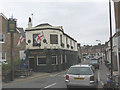
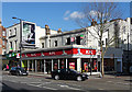
The Leigham Arms, Wellfield Road
This pub proclaims its patriotic credentials not only with the flag of St George but also with spoof plaques on the wall such as "Ken Livingstone did not live here". It gets good ratings on review websites.
Image: © Stephen Craven
Taken: 26 Aug 2008
0.03 miles
3
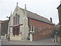
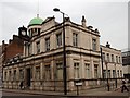
The Refuge Temple, Sunnyhill Road, Streatham
Originally an Anglican church, All Saints, a Chapel of Ease to St Leonard's (the parish church). It was built around 1897 and closed in 1951. It remained in parish use as the Howland Hall until 1968 and is now an Apostolic Church.
Image: © Stephen Craven
Taken: 26 Aug 2008
0.03 miles
4
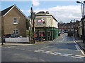
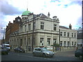
Leigham Arms, Streatham
This view looks across Sunnyhill Road towards Wellfield Road. The Standard describes the Leigham Arms thus: "A country pub somehow dropped into the south London sprawl, the Leigham Arms is a delight." See http://www.standard.co.uk/goingout/bars/leigham-arms-is-a-delightful-country-pub-7414444.html
Image: © Marathon
Taken: 6 Apr 2016
0.03 miles
6
95-99 Streatham High Road
Nos. 97 and 99, well-concealed behind the fast-food outlet are two of the oldest buildings on the High Road. The two-storey buildings date from the late C18th or early C19th and have stucco cornices and window-surrounds, while No. 95, on the left, is Victorian (the shop front is later). They are within the Streatham High Road and Streatham Hill Conservation Area.
The course of Streatham High Road has been a major highway between London and Sussex since Roman times. Its current appearance is largely attributable to two major spells of development. The first was during the late C19th following the opening of Streatham Hill station in 1856, and the second was after 1911 when the line to Victoria was electrified. Though much-maligned and undoubtedly blighted by heavy traffic, closer examination reveals that the road is lined with a number of interesting buildings, some of which reflect the period between the wars when Streatham was a fashionable centre of entertainment. Information from Lambeth Council (http://www.lambeth.gov.uk/NR/exeres/CE4B5CE1-0387-40ED-B5A9-273A5160C34A.htm ).
Image: © Stephen Richards
Taken: Unknown
0.09 miles
7
Streatham Library from the south-west
Image: © tristan forward
Taken: 24 Mar 2010
0.09 miles
8
Streatham Public Library, Streatham High Road.
Corner of A23 and Pinfold Road.
Image: © Noel Foster
Taken: 11 Jul 2005
0.09 miles
9
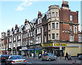
73a-89 Streatham High Road
A fine row of shops and flats, which dates from 1909 and shows a variety of building materials and decorative touches. The block is punctuated by castellated turrets at each end, and has a decorative plaque (Image]) and semi-circular window in the middle. The ironwork on the roof shows touches of Art Nouveau. Also, note the oval window in the return elevation on Sunnyhill Road. It is within the Streatham High Road and Streatham Hill Conservation Area.
The course of Streatham High Road has been a major highway between London and Sussex since Roman times. Its current appearance is largely attributable to two major spells of development. The first was during the late C19th following the opening of Streatham Hill station in 1856, and the second was after 1911 when the line to Victoria was electrified. Though much-maligned and undoubtedly blighted by heavy traffic, closer examination reveals that the road is lined with a number of interesting buildings, some of which reflect the period between the wars when Streatham was a fashionable centre of entertainment. Information from Lambeth Council (http://www.lambeth.gov.uk/NR/exeres/CE4B5CE1-0387-40ED-B5A9-273A5160C34A.htm ).
Image: © Stephen Richards
Taken: Unknown
0.09 miles
10
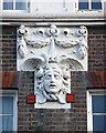
Detail of 73a-89 Streatham High Road
A close-up of a decorative stone carving of the head of Medusa.
See here for a fuller view of the whole building: Image]
Image: © Stephen Richards
Taken: Unknown
0.09 miles