IMAGES TAKEN NEAR TO
Woodleigh Gardens, LONDON, SW16 2SY
Introduction
This page details the photographs taken nearby to Woodleigh Gardens, SW16 2SY by members of the Geograph project.
The Geograph project started in 2005 with the aim of publishing, organising and preserving representative images for every square kilometre of Great Britain, Ireland and the Isle of Man.

There are currently over 7.5m images from over14,400 individuals and you can help contribute to the project by visiting https://www.geograph.org.uk
Image Map
Images are licensed for reuse under creativecommons.org/licenses/by-sa/2.0
Notes
- Clicking on the map will re-center to the selected point.
- The higher the marker number, the further away the image location is from the centre of the postcode.
Image Listing (103 Images Found)
Images are licensed for reuse under creativecommons.org/licenses/by-sa/2.0
Image
Details
Distance
1
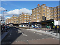
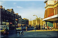
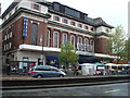
The High, Streatham High Road (1)
The magnum opus of R. Toms and Partners, at least on the High Road. A huge development of street-level shops, above which are five blocks of flats each of five storeys, with more set back from the road. It opened in 1937. The flats have Crittall windows, but overall the buildings are plain with the only decoration being coloured brickwork at the angles, and the canopy above the shops which sweeps distinctively along this stretch of the road. It is within the Streatham High Road and Streatham Hill Conservation Area.
The course of Streatham High Road has been a major highway between London and Sussex since Roman times. Its current appearance is largely attributable to two major spells of development. The first was during the late C19th following the opening of Streatham Hill station in 1856, and the second was after 1911 when the line to Victoria was electrified. Though much-maligned and undoubtedly blighted by heavy traffic, closer examination reveals that the road is lined with a number of interesting buildings, some of which reflect the period between the wars when Streatham was a fashionable centre of entertainment. Information from Lambeth Council (http://www.lambeth.gov.uk/NR/exeres/CE4B5CE1-0387-40ED-B5A9-273A5160C34A.htm ).
Image: © Stephen Richards
Taken: Unknown
0.01 miles
2
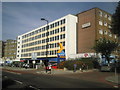
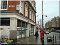
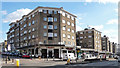
The former British Relay House and later Elgar House, Streatham High Road
This used to be British Relay House, the Southern Area Office of the television rental company British Relay. I worked there on and off between 1965 and 1971 so remember it well as British Relay House when the company occupied the whole building. It later became Elgar House, although any connection with the composer was somewhat remote. The photograph is taken from the middle reservation of the dual carriageway.
By 2014 any mention of Elgar House had gone and instead the sign in its place said "PRS for MUSIC". This is a a UK copyright collection society and performance rights organisation.
Image: © Marathon
Taken: 1 Sep 2010
0.03 miles
3
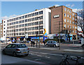
Elgar House, Streatham High Road
Dating from the 1960s, the work of one William Clark of Pall Mall. A car workshop occupies the ground floor, with offices above and flats in the red-brick section. It is within the Streatham High Road and Streatham Hill Conservation Area, but presumably only because it is on the High Road: the report comments that it is "monotonous" and creates a "deadening break ... breaking the sweep of grand apartment blocks and disrupting the pavement frontage of shops."
The course of Streatham High Road has been a major highway between London and Sussex since Roman times. Its current appearance is largely attributable to two major spells of development. The first was during the late C19th following the opening of Streatham Hill station in 1856, and the second was after 1911 when the line to Victoria was electrified. Though much-maligned and undoubtedly blighted by heavy traffic, closer examination reveals that the road is lined with a number of interesting buildings, some of which reflect the period between the wars when Streatham was a fashionable centre of entertainment. Information from Lambeth Council (http://www.lambeth.gov.uk/NR/exeres/CE4B5CE1-0387-40ED-B5A9-273A5160C34A.htm ).
Image: © Stephen Richards
Taken: Unknown
0.03 miles
4
Streatham High Road, summer 1978
Photo taken looking north towards Streatham Hill. To the left is the Odeon and at this time it was still a single screen When opened in 1930, its exotic interiors made it an "atmospheric" where the audience could escape into mock Egyptian fantasy! in the background can be seen "The High", a 1930's mansion block with integral swimming pool. Note the light traffic. It is the constant grind of heavy traffic that contributed to the decline of this once thriving shopping centre.
Image: © Brian Whittle
Taken: Unknown
0.05 miles
6
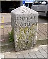
Old Milestone by the A23, Streatham High Road, Streatham parish
Carved stone post by the A23, in parish of STREATHAM (LAMBETH District), Streatham High Road, in front of Kwik-fit garage, between footpath and parking area, to left of seat, on East side of road. Surrey limestone pillar, erected by the Surrey & Sussex turnpike trust in the 18th century.
Inscription reads:-
: WHITEHALL / 5(½) / MILES : : ROYAL / EXCHANGE / 6 / MILES :
Milestone Society National ID: SY_LBT05a.
Image: © DJ Whines
Taken: 21 Sep 2001
0.06 miles
9
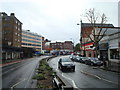
The High, Streatham High Road (2)
Another view (see here: Image]), looking south from opposite the corner of Leigham Avenue.
Image: © Stephen Richards
Taken: Unknown
0.06 miles