IMAGES TAKEN NEAR TO
Charwood, Leigham Court Road, LONDON, SW16 2SA
Introduction
This page details the photographs taken nearby to Charwood, Leigham Court Road, SW16 2SA by members of the Geograph project.
The Geograph project started in 2005 with the aim of publishing, organising and preserving representative images for every square kilometre of Great Britain, Ireland and the Isle of Man.

There are currently over 7.5m images from over14,400 individuals and you can help contribute to the project by visiting https://www.geograph.org.uk
Image Map
Images are licensed for reuse under creativecommons.org/licenses/by-sa/2.0
Notes
- Clicking on the map will re-center to the selected point.
- The higher the marker number, the further away the image location is from the centre of the postcode.
Image Listing (68 Images Found)
Images are licensed for reuse under creativecommons.org/licenses/by-sa/2.0
Image
Details
Distance
1
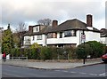
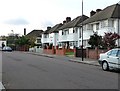
Houses, Leigham Court Road
There are a few pockets of 1920s/1930s houses in this area. The one on the right is an immaculately preserved example with a lot of original features, including the Crittall windows. In most cases these have been replaced by modern uPVC windows which unfortunately mar the appearance even if the reasons for installing them are understandable.
Image: © Stephen Richards
Taken: Unknown
0.02 miles
2
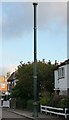
Stink pipe, St Julian's Farm Road
If I'd thought about this at all, I'd vaguely assumed it was an old street lamp, albeit without the lamp part. That is, until an internet search elicited the fact that this is probably one of the better surviving examples of a stink pipe, used to carry away noxious gases from the sewers. Despite its utterly unromantic function it is highly decorative with a crown at the top and a number of gilded bands. A plate at the bottom indicates that it was built by "J. Stone & Co, Engineers, Deptford, London SE".
A close-up of the base can be seen here: Image
Image: © Stephen Richards
Taken: Unknown
0.04 miles
3
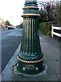
Detail of stink pipe, St Julian's Farm Road
The decorative base of the stink pipe at the top of the road. It shows that no structure was too humble for decoration to be lavished upon it.
A fuller view can be seen here: Image
Image: © Stephen Richards
Taken: Unknown
0.05 miles
4
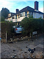
Very off-street parking, Leigham Court Road
I'm not sure what happened here, except that a Polo ended up in the front garden of the best-preserved 1930s house in the area. Fortunately the house was untouched, and temporarily boasts a new vista of the junction of Leigham Court Road and St Julian's Farm Road.
Image: © Stephen Richards
Taken: 1 Aug 2018
0.05 miles
5
St Julian's Farm Road (1)
There are a few pockets of 1920s/1930s houses in this area. (Note how the windows continue round the curve of the bay.) The one on the right still has the original metal Crittall windows. In most cases these have been replaced by modern uPVC windows which unfortunately mar the appearance even if the reasons for installing them are understandable.
This is at the top end of St Julian's Farm Road near the junction with Leigham Court Road.
Image: © Stephen Richards
Taken: Unknown
0.05 miles
6

291 Leigham Court Road
One of the houses within the Leigham Court Road (South) Conservation Area.
Leigham Court Road was laid out in 1839, and while development began in the early 1840s, it didn’t really take off until after the building of the Crystal Palace and West End Railway and the opening of Streatham Hill station in 1856. Quite a number of the original, large Victorian houses survive at either end of the road, and even though their grounds have in some cases since been built on, the remaining mature trees and general landscaping have enabled the area to retain “much of its original arcadian character.” Information from Lambeth Council (http://www.lambeth.gov.uk/NR/exeres/CE4B5CE1-0387-40ED-B5A9-273A5160C34A.htm )
Image: © Stephen Richards
Taken: Unknown
0.05 miles
7
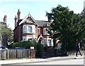
293 Leigham Court Road
One of the houses within the Leigham Court Road (South) Conservation Area.
Leigham Court Road was laid out in 1839, and while development began in the early 1840s, it didn’t really take off until after the building of the Crystal Palace and West End Railway and the opening of Streatham Hill station in 1856. Quite a number of the original, large Victorian houses survive at either end of the road, and even though their grounds have in some cases since been built on, the remaining mature trees and general landscaping have enabled the area to retain “much of its original arcadian character.” Information from Lambeth Council (http://www.lambeth.gov.uk/NR/exeres/CE4B5CE1-0387-40ED-B5A9-273A5160C34A.htm )
Image: © Stephen Richards
Taken: Unknown
0.06 miles
8
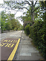
Leigham Court Road
A leafy road in Streatham, South London.
Image: © Billy Shearer
Taken: 7 Aug 2006
0.06 miles
9
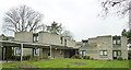
269 Leigham Court Road Sheltered Estate
Flats commissioned by London Borough of Lambeth from architect, Kate Macintosh, designed for older tenants. The Estate was opened in 1975 and given a Grade II Listing, 29 May 2015.
Image: © Deirdre Shaw
Taken: 12 Jan 2013
0.07 miles
10
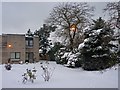
269 Leigham Court Road Flats
Winter December 2010
Image: © Deirdre Shaw
Taken: 2 Dec 2010
0.08 miles