IMAGES TAKEN NEAR TO
Namba Roy Close, LONDON, SW16 2QD
Introduction
This page details the photographs taken nearby to Namba Roy Close, SW16 2QD by members of the Geograph project.
The Geograph project started in 2005 with the aim of publishing, organising and preserving representative images for every square kilometre of Great Britain, Ireland and the Isle of Man.

There are currently over 7.5m images from over14,400 individuals and you can help contribute to the project by visiting https://www.geograph.org.uk
Image Map
Images are licensed for reuse under creativecommons.org/licenses/by-sa/2.0
Notes
- Clicking on the map will re-center to the selected point.
- The higher the marker number, the further away the image location is from the centre of the postcode.
Image Listing (51 Images Found)
Images are licensed for reuse under creativecommons.org/licenses/by-sa/2.0
Image
Details
Distance
1
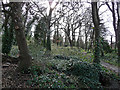
Unigate Wood, Valley Road (1)
So called because it lay next to a Unigate depot, successor to the Curtis Brothers' dairy. Originally this small deciduous wood may have been attached to Well House, which was well known as a spa in the early C19th. In fact, the spa may have been in the wood. As a council sign points out, woodland is rare in Lambeth - this patch is easy to miss - and the site is managed by the council.
Image: © Stephen Richards
Taken: 16 Feb 2011
0.02 miles
2
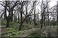
Unigate Wood, Valley Road (3)
So called because it lay next to a Unigate depot, successor to the Curtis Brothers' dairy. Originally this small deciduous wood may have been attached to Well House, which was well known as a spa in the early C19th. In fact, the spa may have been in the wood. As a council sign points out, woodland is rare in Lambeth - this patch is easy to miss - and the site is managed by the council.
Image: © Stephen Richards
Taken: 16 Feb 2011
0.02 miles
3
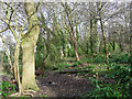
Unigate Wood, Valley Road (2)
So called because it lay next to a Unigate depot, successor to the Curtis Brothers' dairy. Originally this small deciduous wood may have been attached to Well House, which was well known as a spa in the early C19th. In fact, the spa may have been in the wood. As a council sign points out, woodland is rare in Lambeth - this patch is easy to miss - and the site is managed by the council.
Image: © Stephen Richards
Taken: 16 Feb 2011
0.03 miles
4
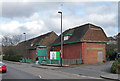
The Old Dairy
A new housing development by Bellway Homes on Valley Road.
Image: © Bill Boaden
Taken: 1 Feb 2014
0.03 miles
5
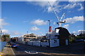
Dairy, Valley Road
These days it is really just a distribution centre for local deliveries and won't have even had a whiff of a cow for many years. But there has been a dairy in these parts since the early C19th when the Curtis Brothers delivered milk and mineral waters from the Well House spa.
Image: © Stephen Richards
Taken: 16 Feb 2011
0.04 miles
6
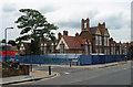
School, Sunnyhill Road
A good Board School, dated c1900, multi-gabled and extravagantly chimneyed. Grade II listed.
Now Sunnyhill Primary School.
Image: © Stephen Richards
Taken: 29 Aug 2015
0.05 miles
7
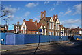
Sunnyhill Primary School
Still occupying its traditional building dating from 1900.
Image: © Bill Boaden
Taken: 1 Feb 2014
0.05 miles
8
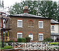
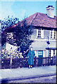
Well House, Valley Road
An early C19th relic of Streatham's days as a spa resort, once standing in a local dairy (Image]) but now incorporated into a sheltered housing complex. Grade II listed.
Image: © Stephen Richards
Taken: 29 Aug 2015
0.05 miles
9
22 Etherstone Green
This is a small crescent of terraced houses round a small green area just off Leigham Court Rd.
Image: © Nigel Mykura
Taken: 12 Jul 1953
0.10 miles
10
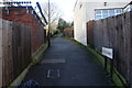
Wellfield Walk
A useful cut through between Valley Road and Springwell Road.
Image: © Bill Boaden
Taken: 1 Feb 2014
0.11 miles