IMAGES TAKEN NEAR TO
Oakdale Road, LONDON, SW16 2HJ
Introduction
This page details the photographs taken nearby to Oakdale Road, SW16 2HJ by members of the Geograph project.
The Geograph project started in 2005 with the aim of publishing, organising and preserving representative images for every square kilometre of Great Britain, Ireland and the Isle of Man.

There are currently over 7.5m images from over14,400 individuals and you can help contribute to the project by visiting https://www.geograph.org.uk
Image Map
Images are licensed for reuse under creativecommons.org/licenses/by-sa/2.0
Notes
- Clicking on the map will re-center to the selected point.
- The higher the marker number, the further away the image location is from the centre of the postcode.
Image Listing (42 Images Found)
Images are licensed for reuse under creativecommons.org/licenses/by-sa/2.0
Image
Details
Distance
5
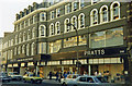
Pratts Department Store. Summer 1978
This was taken one afternoon in the summer of 1978. The closure of Pratts in July 1990 was a blow to the High Road from which it never recovered. It was demolished in the early '90s and replaced by a bland new building containing a Lidl supermarket and Peacocks clothing store, a sign of social change in Streatham? Ironically, the new building has a rear car-park, something the John Lewis Partnership pushed for without success thus using it as a pretext for closure. The lights seen through the second floor windows are those of the highly popular restaurant where, on Saturdays, the queue would snake down the staircase to the first floor. Before refurbishment in the 1980s an art deco wood panelled lift complete with setting sun stained glass and an operator would creak its way up.
Image: © Brian Whittle
Taken: Unknown
0.10 miles
7
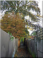
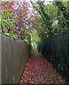
Russell's Footpath (1)
The path runs in three stages between Streatham Station on the High Road and Leigham Court Road (almost). This bit joins Madeira Road and Valley Road, running between back gardens of houses on Oakdale and Hopton Roads.
Image: © Stephen Richards
Taken: 24 Oct 2012
0.11 miles
10
Russell's Footpath (2)
The path runs in three stages between Streatham Station on the High Road and Leigham Court Road (almost). This bit joins Valley Road and Strathdale, running between back gardens of houses on Valleyfield Road and the grounds of Bishop Thomas Grant School (right).
Image: © Stephen Richards
Taken: 24 Oct 2012
0.12 miles