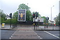
IMAGES TAKEN NEAR TO
Polworth Road, LONDON, SW16 2EE
Introduction
This page details the photographs taken nearby to Polworth Road, SW16 2EE by members of the Geograph project.
The Geograph project started in 2005 with the aim of publishing, organising and preserving representative images for every square kilometre of Great Britain, Ireland and the Isle of Man.

There are currently over 7.5m images from over14,400 individuals and you can help contribute to the project by visiting https://www.geograph.org.uk
Image Map
Images are licensed for reuse under creativecommons.org/licenses/by-sa/2.0
Notes
- Clicking on the map will re-center to the selected point.
- The higher the marker number, the further away the image location is from the centre of the postcode.
Image Listing (128 Images Found)
Images are licensed for reuse under creativecommons.org/licenses/by-sa/2.0
Image
Details
Distance
3

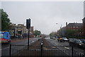
1930s building, Streatham
This is on the east side of Streatham High Road, No.245, opposite the Tesco Extra store. It isn't listed.
Photo number 7589784.
Image: © Robin Stott
Taken: 2 Sep 2023
0.07 miles
4

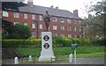
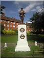
War Memorial, Streatham High Road, SW16
I too like other contributors have often wondered if this memorial has/had anything to do with the fallen who worked for London Transport?
Image: © Phillip Perry
Taken: 19 Aug 2007
0.08 miles
5
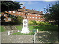
Streatham War Memorial and Memorial Gardens
Situated on Streatham High Road opposite Streatham Common, the war memorial consists of a bronze soldier with his rifle upturned. It was unveiled in 1922 and is located in a small garden.
Image: © Marathon
Taken: 3 Sep 2010
0.08 miles
6
Streatham War Memorial
Situated in Streatham Memorial Garden on Streatham High Road opposite Streatham Common, the war memorial consists of a bronze soldier with his rifle upturned. It was unveiled in 1922.
The site was once occupied by a large house called Colbrands which dated back to the early 15th century. The old house was demolished after 1805 and a new villa called Coventry Hall was built. In 1919, part of the Estate was bought by the Rector of Streatham and other trustees of the local war memorial committee. The site was then laid out as a War Memorial Garden. It also now includes a contemporary sculpture in the form of an obelisk and plinth which commemorates people of all races, faiths and nationalities living or who have lived in Streatham and have been affected by violent conflicts or wars, wherever they have occurred.
The information board can be seen at www.geograph.org.uk/photo/7487415
Image: © Marathon
Taken: 3 Sep 2010
0.08 miles
7
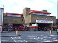
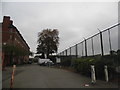
Former bus garage
The former Streatham bus garage, reopened in 1987 after being totally rebuilt, yet closed after just 5 years. The side court is still used as a bus terminus, but no buses are garaged here.
Image: © Malc McDonald
Taken: 6 Mar 2010
0.08 miles
8

Ice Rink, Streatham High Road
A fine building which immediately evokes the 1930s (the current colour scheme is fairly recent). Long and low in a "moderne" style, its horizontality counterbalanced by tall, narrow windows. At the ends are Art Deco doorways below keystoned windows. The architect was Robert Cromie who usually specialised in cinemas. The rink itself covers 21,000 sq ft, enough for 1,000 skaters. They'll have to find somewhere else to go for a time as the ice rink is scheduled for demolition as part of the Streatham Hub development. It is within the Streatham High Road and Streatham Hill Conservation Area.
The course of Streatham High Road has been a major highway between London and Sussex since Roman times. Its current appearance is largely attributable to two major spells of development. The first was during the late C19th following the opening of Streatham Hill station in 1856, and the second was after 1911 when the line to Victoria was electrified. Though much-maligned and undoubtedly blighted by heavy traffic, closer examination reveals that the road is lined with a number of interesting buildings, some of which reflect the period between the wars when Streatham was a fashionable centre of entertainment. Information from Lambeth Council (http://www.lambeth.gov.uk/NR/exeres/CE4B5CE1-0387-40ED-B5A9-273A5160C34A.htm ).
Update: demolished in late 2011.
Image: © Stephen Richards
Taken: Unknown
0.08 miles