
IMAGES TAKEN NEAR TO
Madeira Road, LONDON, SW16 2DG
Introduction
This page details the photographs taken nearby to Madeira Road, SW16 2DG by members of the Geograph project.
The Geograph project started in 2005 with the aim of publishing, organising and preserving representative images for every square kilometre of Great Britain, Ireland and the Isle of Man.

There are currently over 7.5m images from over14,400 individuals and you can help contribute to the project by visiting https://www.geograph.org.uk
Image Map
Images are licensed for reuse under creativecommons.org/licenses/by-sa/2.0
Notes
- Clicking on the map will re-center to the selected point.
- The higher the marker number, the further away the image location is from the centre of the postcode.
Image Listing (123 Images Found)
Images are licensed for reuse under creativecommons.org/licenses/by-sa/2.0
Image
Details
Distance
1
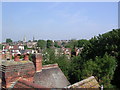
Streatham roof tops
View over Streatham roof tops towards St Leonards and English Martyrs churches. Taken from my roof in Hopton Road, Streatham.
Image: © Nicky Johns
Taken: 3 Jun 2007
0.03 miles
2
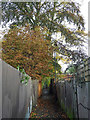
Russell's Footpath (1)
The path runs in three stages between Streatham Station on the High Road and Leigham Court Road (almost). This bit joins Madeira Road and Valley Road, running between back gardens of houses on Oakdale and Hopton Roads.
Image: © Stephen Richards
Taken: 24 Oct 2012
0.09 miles
3
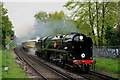
'Clan Line'
No.35028 'Clan Line', approaching Streatham with the 50th Anniversary service from Victoria to Bath Spa.
Image: © Peter Trimming
Taken: 27 Apr 2024
0.09 miles
4
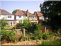
Streatham: backs of houses on Stanthorpe Road, from the train
Image: © Christopher Hilton
Taken: 2 Jun 2011
0.10 miles
5
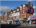
Queen's Parade, Streatham High Road
Built around 1882-1900 in a Queen Anne revival style by Frederick Wheeler, an architect responsible for a number of buildings on the High Road. Some of the buildings have roughcast rendering, pargetted gables, and their original sash windows. Note, too, the canted dormers with their own gables. As the last commercial buildings on the eastern side of the road, Queen's Parade marks the end of the Streatham High Road and Streatham Hill Conservation Area.
The course of Streatham High Road has been a major highway between London and Sussex since Roman times. Its current appearance is largely attributable to two major spells of development. The first was during the late C19th following the opening of Streatham Hill station in 1856, and the second was after 1911 when the line to Victoria was electrified. Though much-maligned and undoubtedly blighted by heavy traffic, closer examination reveals that the road is lined with a number of interesting buildings, some of which reflect the period between the wars when Streatham was a fashionable centre of entertainment. Information from Lambeth Council (http://www.lambeth.gov.uk/NR/exeres/CE4B5CE1-0387-40ED-B5A9-273A5160C34A.htm ).
Image: © Stephen Richards
Taken: Unknown
0.11 miles
6
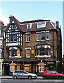
Former Bedford Park Hotel, Streatham High Road
An impressive Victorian pub - 1882 is given on the half-timbering - which closed in early 2009. An application has been made to convert it into commercial premises with shops above. It is within the Streatham High Road and Streatham Hill Conservation Area.
The course of Streatham High Road has been a major highway between London and Sussex since Roman times (the foundations of this building reputedly stand on part of the Roman road). Its current appearance is largely attributable to two major spells of development. The first was during the late C19th following the opening of Streatham Hill station in 1856, and the second was after 1911 when the line to Victoria was electrified. Though much-maligned and undoubtedly blighted by heavy traffic, closer examination reveals that the road is lined with a number of interesting buildings, some of which reflect the period between the wars when Streatham was a fashionable centre of entertainment. Information from Lambeth Council (http://www.lambeth.gov.uk/NR/exeres/CE4B5CE1-0387-40ED-B5A9-273A5160C34A.htm ).
Image: © Stephen Richards
Taken: Unknown
0.12 miles
7
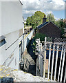
Russell's Footpath, Streatham
Reached by steps from Streatham High Road, off lower right, it runs by the railway then turns east for some distance. It is named on OpenStreetMap.
Photo number 7590103.
Image: © Robin Stott
Taken: 2 Sep 2023
0.13 miles
9

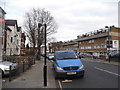
Stanthorpe Road
Houses dating from the second half (probably the last quarter) of the C19th.
Image: © Stephen Richards
Taken: Unknown
0.14 miles
10
Shops and flats on Streatham High Road
Image: © David Howard
Taken: 29 Sep 2013
0.14 miles