IMAGES TAKEN NEAR TO
Woodbourne Avenue, LONDON, SW16 1UU
Introduction
This page details the photographs taken nearby to Woodbourne Avenue, SW16 1UU by members of the Geograph project.
The Geograph project started in 2005 with the aim of publishing, organising and preserving representative images for every square kilometre of Great Britain, Ireland and the Isle of Man.

There are currently over 7.5m images from over14,400 individuals and you can help contribute to the project by visiting https://www.geograph.org.uk
Image Map
Images are licensed for reuse under creativecommons.org/licenses/by-sa/2.0
Notes
- Clicking on the map will re-center to the selected point.
- The higher the marker number, the further away the image location is from the centre of the postcode.
Image Listing (95 Images Found)
Images are licensed for reuse under creativecommons.org/licenses/by-sa/2.0
Image
Details
Distance
3
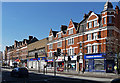
138-184 Streatham High Road
A long terrace mostly dating from 1905 and running from Woodbourne Avenue to Becmead Avenue, and probably the main run of shops on the High Road. Like all the blocks in the area it has turrets at the corners and decorative stonework, plus a variety of shaped gables. The exception in the foreground with its blank brick front used to be Woolworths and dates from 1957. The other exception can be seen here: Image The whole terrace is within the Streatham High Road and Streatham Hill Conservation Area.
The course of Streatham High Road has been a major highway between London and Sussex since Roman times. Its current appearance is largely attributable to two major spells of development. The first was during the late C19th following the opening of Streatham Hill station in 1856, and the second was after 1911 when the line to Victoria was electrified. Though much-maligned and undoubtedly blighted by heavy traffic, closer examination reveals that the road is lined with a number of interesting buildings, some of which reflect the period between the wars when Streatham was a fashionable centre of entertainment. Information from Lambeth Council (http://www.lambeth.gov.uk/NR/exeres/CE4B5CE1-0387-40ED-B5A9-273A5160C34A.htm ).
Image: © Stephen Richards
Taken: Unknown
0.09 miles
4
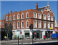
136 Streatham High Road
Until quite recently the Post Office, and before that the telephone exchange, this is a fine neo-Georgian building of red brick with stone dressings. The windows facing the High Road have stone surrounds and pronounced keystones, and there is a gable topped by an obelisk (the bird is not a permanent feature). It was built in 1909. It is within the Streatham High Road and Streatham Hill Conservation Area.
The course of Streatham High Road has been a major highway between London and Sussex since Roman times. Its current appearance is largely attributable to two major spells of development. The first was during the late C19th following the opening of Streatham Hill station in 1856, and the second was after 1911 when the line to Victoria was electrified. Though much-maligned and undoubtedly blighted by heavy traffic, closer examination reveals that the road is lined with a number of interesting buildings, some of which reflect the period between the wars when Streatham was a fashionable centre of entertainment. Information from Lambeth Council (http://www.lambeth.gov.uk/NR/exeres/CE4B5CE1-0387-40ED-B5A9-273A5160C34A.htm ).
Image: © Stephen Richards
Taken: Unknown
0.09 miles
7
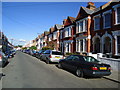
116-134 Streatham High Road
No. 116 on the right, dating from c1901, is another lively, turreted building similar to those of the two blocks to the north. The single-storey Nos. 118-134 date from c1922. The Golden Domes cinema stood at the left end and its rear portions survive. The whole group is within the Streatham High Road and Streatham Hill Conservation Area.
The course of Streatham High Road has been a major highway between London and Sussex since Roman times. Its current appearance is largely attributable to two major spells of development. The first was during the late C19th following the opening of Streatham Hill station in 1856, and the second was after 1911 when the line to Victoria was electrified. Though much-maligned and undoubtedly blighted by heavy traffic, closer examination reveals that the road is lined with a number of interesting buildings, some of which reflect the period between the wars when Streatham was a fashionable centre of entertainment. Information from Lambeth Council (http://www.lambeth.gov.uk/NR/exeres/CE4B5CE1-0387-40ED-B5A9-273A5160C34A.htm ).
Image: © Stephen Richards
Taken: Unknown
0.10 miles
9
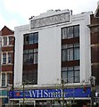
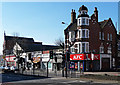
WHSmith's, Streatham High Road
Lift your eyes from the pavement and even in the most unpromising of places, all kinds of delights will reveal themselves to you.
Above WHSmith's is a fine 1930s Art Deco style front. Note the stepped pediment at the top, vertical panels of windows, and the multi-paned leaded casements with decorative bands, the whole facade being set within an ornamental frame.
Sharman's was a dress shop and drapers, no doubt dating from the time when Streatham was known as the "West End of South London". See here for a view of the whole terrace: Image]
Image: © Stephen Richards
Taken: 23 Jul 2009
0.11 miles
10
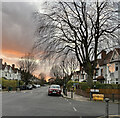
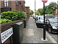
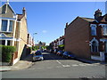
Becmead Avenue
A street of mostly 1930s detached and semi-detached houses connecting Streatham High Road (behind) and Garrad's Road.
A rare sliver of winter sunshine in a mostly drab December.
Image: © Stephen Richards
Taken: 21 Dec 2024
0.11 miles