IMAGES TAKEN NEAR TO
Thirlmere Road, LONDON, SW16 1QW
Introduction
This page details the photographs taken nearby to Thirlmere Road, SW16 1QW by members of the Geograph project.
The Geograph project started in 2005 with the aim of publishing, organising and preserving representative images for every square kilometre of Great Britain, Ireland and the Isle of Man.

There are currently over 7.5m images from over14,400 individuals and you can help contribute to the project by visiting https://www.geograph.org.uk
Image Map
Images are licensed for reuse under creativecommons.org/licenses/by-sa/2.0
Notes
- Clicking on the map will re-center to the selected point.
- The higher the marker number, the further away the image location is from the centre of the postcode.
Image Listing (155 Images Found)
Images are licensed for reuse under creativecommons.org/licenses/by-sa/2.0
Image
Details
Distance
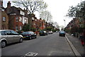
1
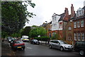
Houses on Riggindale Rd
The route of the Capital Ring/
Image: © N Chadwick
Taken: 8 May 2010
0.04 miles
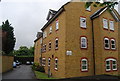
4
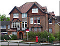
55 Tooting Bec Gardens
A large Arts and Craft-style house with tile-hanging, 'nine-over-one' and 'twelve-over-one' windows, and a central carved stone panel. Like many such houses it is now sub-divided into flats.
One of a number of large houses near Tooting Bec Common dating from the late C19th/early C20th.
Image: © Stephen Richards
Taken: Unknown
0.06 miles

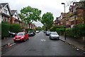
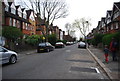
8
Riggindale Rd
Route of the Capital Ring walk.
Image: © N Chadwick
Taken: 30 Mar 2014
0.07 miles
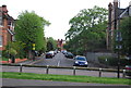
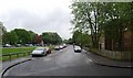
10
Tooting Bec Common by Garrad's Road bus stop
Image: © Robin Webster
Taken: 19 Nov 2011
0.08 miles