IMAGES TAKEN NEAR TO
Streatham High Road, LONDON, SW16 1DD
Introduction
This page details the photographs taken nearby to Streatham High Road, SW16 1DD by members of the Geograph project.
The Geograph project started in 2005 with the aim of publishing, organising and preserving representative images for every square kilometre of Great Britain, Ireland and the Isle of Man.

There are currently over 7.5m images from over14,400 individuals and you can help contribute to the project by visiting https://www.geograph.org.uk
Image Map
Images are licensed for reuse under creativecommons.org/licenses/by-sa/2.0
Notes
- Clicking on the map will re-center to the selected point.
- The higher the marker number, the further away the image location is from the centre of the postcode.
Image Listing (132 Images Found)
Images are licensed for reuse under creativecommons.org/licenses/by-sa/2.0
Image
Details
Distance
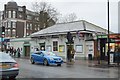
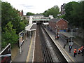
2
Sreatham Hill Station
This station was opened on the then-new West End of London and Crystal Palace railway in 1856, as just plain 'Streatham'. The addition of 'Hill' came in 1869 by which time the line had become part of the London Brighton and South Coast Railway. It remains as a well-used and important part of London's railway network.
Image: © Dr Neil Clifton
Taken: 13 Jul 2012
0.02 miles
3
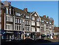
Stonehill Mansions, Streatham High Road
A striking building of dark-brown brick, cream-painted stucco, Doric and Ionic pilasters, and a roofline enlivened by domed towers. It was designed by Meech and Goodall in c1905 and stands on the site of a large house called Stonehills. It is within the Streatham High Road and Streatham Hill Conservation Area.
The course of Streatham High Road has been a major highway between London and Sussex since Roman times. Its current appearance is largely attributable to two major spells of development. The first was during the late C19th following the opening of Streatham Hill station in 1856, and the second was after 1911 when the line to Victoria was electrified. Though much-maligned and undoubtedly blighted by heavy traffic, closer examination reveals that the road is lined with a number of interesting buildings, some of which reflect the period between the wars when Streatham was a fashionable centre of entertainment. Information from Lambeth Council (http://www.lambeth.gov.uk/NR/exeres/CE4B5CE1-0387-40ED-B5A9-273A5160C34A.htm ).
Image: © Stephen Richards
Taken: Unknown
0.02 miles
4
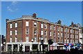
24-36 Streatham High Road
A restrained neo-Georgian block of c1930, animated somewhat by the use of brown brick with red brick dressings. It is within the Streatham High Road and Streatham Hill Conservation Area.
The course of Streatham High Road has been a major highway between London and Sussex since Roman times. Its current appearance is largely attributable to two major spells of development. The first was during the late C19th following the opening of Streatham Hill station in 1856, and the second was after 1911 when the line to Victoria was electrified. Though much-maligned and undoubtedly blighted by heavy traffic, closer examination reveals that the road is lined with a number of interesting buildings, some of which reflect the period between the wars when Streatham was a fashionable centre of entertainment. Information from Lambeth Council (http://www.lambeth.gov.uk/NR/exeres/CE4B5CE1-0387-40ED-B5A9-273A5160C34A.htm ).
Image: © Stephen Richards
Taken: Unknown
0.02 miles
6
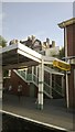
Streatham Hill station, up platform
The canopies and staircase were installed as part of a major refurbishment of the station a couple of years before this photograph was taken, in which the staircases down to the platforms were moved to a more central location and lifts installed.
Image: © Christopher Hilton
Taken: 12 Jul 2013
0.03 miles
7
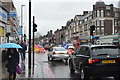
Streatham Hill
Both the name of the road and the district. The road is the A23 between London and Brighton.
Image: © Bill Boaden
Taken: 1 Feb 2014
0.03 miles
8
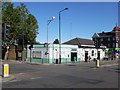
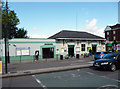
Streatham Hill Station entrance
At the corner of Streatham Hill/High Road and Sternhold Avenue.
Image: © Mike Faherty
Taken: 18 Aug 2012
0.03 miles
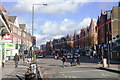
9

Streatham High Road
This splendid large block has, apart from the ground floor, survived amazingly well. It is on the west side of the High Road, and just to the south of Streatham Hill station.
Image: © Dr Neil Clifton
Taken: 13 Jul 2012
0.03 miles
10
Streatham Hill railway station, Greater London
Opened in 1856 by the West End of London & Crystal Palace Railway on what became the line from London Victoria via Balham to Beckenham Junction.
View south east towards West Norwood and Beckenham Junction.
Image: © Nigel Thompson
Taken: 28 May 2015
0.03 miles