IMAGES TAKEN NEAR TO
Upper Richmond Road, LONDON, SW15 6SX
Introduction
This page details the photographs taken nearby to Upper Richmond Road, SW15 6SX by members of the Geograph project.
The Geograph project started in 2005 with the aim of publishing, organising and preserving representative images for every square kilometre of Great Britain, Ireland and the Isle of Man.

There are currently over 7.5m images from over14,400 individuals and you can help contribute to the project by visiting https://www.geograph.org.uk
Image Map
Images are licensed for reuse under creativecommons.org/licenses/by-sa/2.0
Notes
- Clicking on the map will re-center to the selected point.
- The higher the marker number, the further away the image location is from the centre of the postcode.
Image Listing (24 Images Found)
Images are licensed for reuse under creativecommons.org/licenses/by-sa/2.0
Image
Details
Distance
1
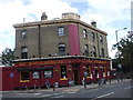
The Northumberland, Upper Richmond Rd, London
Image: © John Lord
Taken: 7 Sep 2010
0.08 miles
2
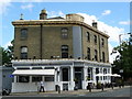
West Putney Tavern
Standing on the junction of Dyers Lane and Upper Richmond Road.
Image: © Peter Trimming
Taken: 17 May 2009
0.08 miles
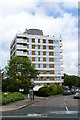
3
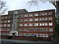
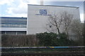
Harwood Court, Putney
Large block of housing on Upper Richomond Road.
Image: © David Anstiss
Taken: 30 Dec 2012
0.09 miles
4
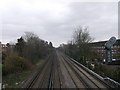
Railway to Putney
As seen from Image
This line leads from Barnes towards Putney.
Image: © David Anstiss
Taken: 30 Dec 2012
0.11 miles
6
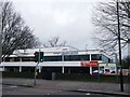
Putney Leisure Centre
On the junction of Upper Richmond Road (in front) and Dryburg Road.
Image: © David Anstiss
Taken: 30 Dec 2012
0.13 miles
7
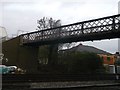
Footbridge near Dyer's Lane, Putney
This bridge connects Dyer's Lane to Lower Common South (road).
It passes over the railway between Putney and Barnes.
Image: © David Anstiss
Taken: 30 Dec 2012
0.14 miles
8
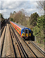
Waterloo Circular
A pair of class 455 electric units, with 5848 leading, depart Barnes on the home leg of the '21' circular route from/to Waterloo via Wimbledon, Kingston and Richmond. This view is from the footbridge connecting Dyer's Lane with Beauchamp Terrace. The Bridge in the distance carries Queen's Ride over the line.
Image: © Martin Addison
Taken: 19 Feb 2016
0.16 miles
9
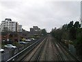
Railway to Barnes
As seen from Image
This line leads from Barnes towards Putney.
In the background is Queen's Ride road bridge.
Image: © David Anstiss
Taken: 30 Dec 2012
0.16 miles
10
Flats in Warwick Drive, Putney
Away from the centre of Putney, the character of the housing changes.
Image: © Peter Trimming
Taken: 17 May 2009
0.16 miles