IMAGES TAKEN NEAR TO
Sherfield Gardens, LONDON, SW15 4PP
Introduction
This page details the photographs taken nearby to Sherfield Gardens, SW15 4PP by members of the Geograph project.
The Geograph project started in 2005 with the aim of publishing, organising and preserving representative images for every square kilometre of Great Britain, Ireland and the Isle of Man.

There are currently over 7.5m images from over14,400 individuals and you can help contribute to the project by visiting https://www.geograph.org.uk
Image Map
Images are licensed for reuse under creativecommons.org/licenses/by-sa/2.0
Notes
- Clicking on the map will re-center to the selected point.
- The higher the marker number, the further away the image location is from the centre of the postcode.
Image Listing (112 Images Found)
Images are licensed for reuse under creativecommons.org/licenses/by-sa/2.0
Image
Details
Distance
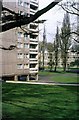
1
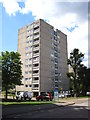
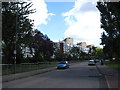
High rise flats on Tunworth Crescent
Built in 1959 by the London County Council the architecture of the Alton West Estate was influenced by the ideas of French architect Le Corbusier. http://modernarchitecturelondon.com/pages/alton-west.php
Image: © Chris Holifield
Taken: 9 Aug 2014
0.04 miles
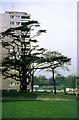
5
Alton West Estate, Roehampton, 1966 ? 7
Image: © Alan Murray-Rust
Taken: 25 Apr 1966
0.05 miles
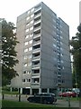
6
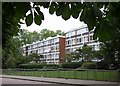
Flats on the Tunworth estate, Roehampton
Flats on Sherfield Gardens, seen from across Danebury Avenue.
Image: © Derek Harper
Taken: 1 Aug 2009
0.06 miles
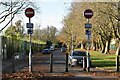
7
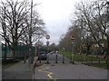
Blockage on Danebury Avenue, Roehampton
This long road leads from the A308 Roehampton Lane, towards several housing estates and a small group of shops, the road then heads to past 2 schools to Priory Lane. It is blocked for road traffic beside a primary school (on the left).
Image: © David Anstiss
Taken: 30 Dec 2012
0.06 miles
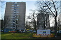
8
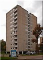
Bramley House, Alton West Estate, Roehampton
Image: © Jim Osley
Taken: 10 Oct 2015
0.06 miles
9
Danebury Avenue, Roehampton
The low-rise Sherfield Gardens flats are to the left with the slab blocks of the Alton West estate beyond. http://modernarchitecturelondon.com/pages/alton-west.php
Image: © Chris Holifield
Taken: 9 Aug 2014
0.06 miles
10
Alton West Estate, Roehampton, 1966 ? 8
Image: © Alan Murray-Rust
Taken: 25 Apr 1966
0.07 miles