IMAGES TAKEN NEAR TO
Swanwick Close, LONDON, SW15 4EF
Introduction
This page details the photographs taken nearby to Swanwick Close, SW15 4EF by members of the Geograph project.
The Geograph project started in 2005 with the aim of publishing, organising and preserving representative images for every square kilometre of Great Britain, Ireland and the Isle of Man.

There are currently over 7.5m images from over14,400 individuals and you can help contribute to the project by visiting https://www.geograph.org.uk
Image Map
Images are licensed for reuse under creativecommons.org/licenses/by-sa/2.0
Notes
- Clicking on the map will re-center to the selected point.
- The higher the marker number, the further away the image location is from the centre of the postcode.
Image Listing (81 Images Found)
Images are licensed for reuse under creativecommons.org/licenses/by-sa/2.0
Image
Details
Distance
1
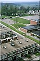
Alton West Estate, Roehampton, 1966 ? 12
Image: © Alan Murray-Rust
Taken: 25 Apr 1966
0.03 miles
2
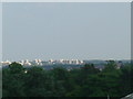
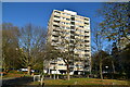
Alton Estate - Roehampton, SW15
Taken from the Treetops Walkway in the middle of Kew Gardens is the Alton Estate built in the mid 1950's.
Image: © Phillip Perry
Taken: 9 Jun 2008
0.04 miles
4
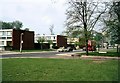
Alton West Estate, Roehampton, 1966 ? 10
Image: © Alan Murray-Rust
Taken: 25 Apr 1966
0.07 miles
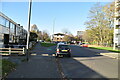
7
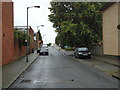
Tangley Grove looking towards Danebury Avenue
Image: © David Howard
Taken: 28 Sep 2014
0.08 miles
9

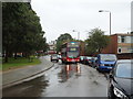
Tangley Grove, Roehampton
Tangley Grove in Roehampton, in south west London. The road forms part of a housing estate.
Image: © Malc McDonald
Taken: 9 Jul 2016
0.08 miles
10
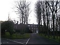
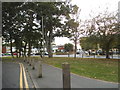
Maryfield Convent, Roehampton
As seen from Laverstock Gardens.
Image: © David Anstiss
Taken: 30 Dec 2012
0.09 miles