IMAGES TAKEN NEAR TO
Roehampton Lane, LONDON, SW15 4AA
Introduction
This page details the photographs taken nearby to Roehampton Lane, SW15 4AA by members of the Geograph project.
The Geograph project started in 2005 with the aim of publishing, organising and preserving representative images for every square kilometre of Great Britain, Ireland and the Isle of Man.

There are currently over 7.5m images from over14,400 individuals and you can help contribute to the project by visiting https://www.geograph.org.uk
Image Map
Images are licensed for reuse under creativecommons.org/licenses/by-sa/2.0
Notes
- Clicking on the map will re-center to the selected point.
- The higher the marker number, the further away the image location is from the centre of the postcode.
Image Listing (90 Images Found)
Images are licensed for reuse under creativecommons.org/licenses/by-sa/2.0
Image
Details
Distance
2
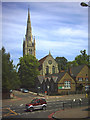
Holy Trinity Church, Roehampton.
In front of the Church is Roehampton C of E Primary School.
Image: © Noel Foster
Taken: 23 Jun 2005
0.06 miles
5
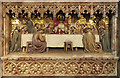
Holy Trinity, Ponsonby Road, Roehampton - Font bowl detail
Image: © John Salmon
Taken: 7 Mar 2017
0.06 miles
6
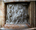
Holy Trinity, Ponsonby Road, Roehampton - Reredos detail
Image: © John Salmon
Taken: 7 Mar 2017
0.06 miles
7
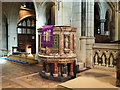
Holy Trinity, Ponsonby Road, Roehampton - Pulpit
Image: © John Salmon
Taken: 7 Mar 2017
0.06 miles
8
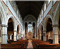
Holy Trinity, Ponsonby Road, Roehampton - East end
Image: © John Salmon
Taken: 7 Mar 2017
0.06 miles
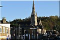
9
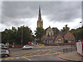
Roehampton: Holy Trinity Church
On Ponsonby Road
Image: © Dr Neil Clifton
Taken: 23 Jun 2013
0.06 miles
10
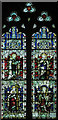
Holy Trinity, Ponsonby Road, Roehampton - Stained glass window
Image: © John Salmon
Taken: 7 Mar 2017
0.06 miles