IMAGES TAKEN NEAR TO
Kingston Vale, LONDON, SW15 3PF
Introduction
This page details the photographs taken nearby to Kingston Vale, SW15 3PF by members of the Geograph project.
The Geograph project started in 2005 with the aim of publishing, organising and preserving representative images for every square kilometre of Great Britain, Ireland and the Isle of Man.

There are currently over 7.5m images from over14,400 individuals and you can help contribute to the project by visiting https://www.geograph.org.uk
Image Map
Images are licensed for reuse under creativecommons.org/licenses/by-sa/2.0
Notes
- Clicking on the map will re-center to the selected point.
- The higher the marker number, the further away the image location is from the centre of the postcode.
Image Listing (117 Images Found)
Images are licensed for reuse under creativecommons.org/licenses/by-sa/2.0
Image
Details
Distance
1
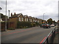
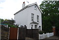
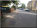
Houses on Kingston Vale
At the junction of the A3
Image: © David Howard
Taken: 28 Sep 2014
0.02 miles
2
Kingston Vale
Like New York New York it's the name of the road and the area, but in London SW15 rather than Surrey like the rest of Kingston.
Image: © David Howard
Taken: 28 Sep 2014
0.03 miles
3

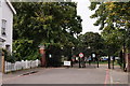
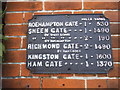
Richmond Park: Robin Hood Gate
This gate allows access to the park for pedestrians, cyclists and horse riders, but not for the general public in motor vehicles, at its south eastern corner by the A3. At one time motor traffic was allowed through but southbound traffic was stopped some time ago and from 2003 northbound traffic has been prohibited too.
The black plate on the left side brick pier gives distances in miles and yards to the other gates in the park.
Image: © Nigel Cox
Taken: 30 Jan 2008
0.03 miles
4
Ancient direction sign on Robin Hood Gate
The sign is probably Victorian and could be Britain's oldest direction sign besides the many surviving fingerposts. I have since been told the distance for Kingston Gate is more than Ham Gate is because the original direct road has since been closed to traffic.
Image: © David Howard
Taken: 22 Jun 2015
0.03 miles
5

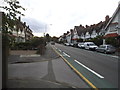
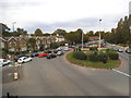
The A3 at the junction of Kinsgston Vale
I have memories of this starting off as a roundabout but I may be wrong.
Image: © David Howard
Taken: 28 Sep 2014
0.04 miles
6
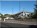
The A3 at the junction of Kingston Vale
There is no right turn from Kingston Vale, so traffic wishing to turn south to the A3 must go north and take the underpass at Putney Vale and turn round to join the southbound carriageway. I imagine this came in once the underpass was built and previously this would probably have been a full junction, possibly using the large central reservation ahead as a roundabout.
Image: © David Howard
Taken: 28 Sep 2014
0.04 miles
7
Ramped footbridge over the A3
The footbridge is at the "Robin Hood" junction of the A3 dual carriageway (where it becomes the Kingston Bypass) and the old Kingston Road. Another photograph for this square - Image - is obviously taken from this bridge.
Image: © Stephen Craven
Taken: 26 Apr 2009
0.04 miles
8
The old road entrance to Robin Hood Gate
This is now closed to all through traffic except cycles and horses
Image: © David Howard
Taken: 22 Jun 2015
0.04 miles