IMAGES TAKEN NEAR TO
Cortis Road, LONDON, SW15 3AF
Introduction
This page details the photographs taken nearby to Cortis Road, SW15 3AF by members of the Geograph project.
The Geograph project started in 2005 with the aim of publishing, organising and preserving representative images for every square kilometre of Great Britain, Ireland and the Isle of Man.

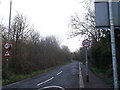
There are currently over 7.5m images from over14,400 individuals and you can help contribute to the project by visiting https://www.geograph.org.uk
Image Map
Images are licensed for reuse under creativecommons.org/licenses/by-sa/2.0
Notes
- Clicking on the map will re-center to the selected point.
- The higher the marker number, the further away the image location is from the centre of the postcode.
Image Listing (25 Images Found)
Images are licensed for reuse under creativecommons.org/licenses/by-sa/2.0
Image
Details
Distance
1
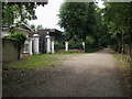
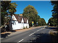
Putney Park Lane
Putney Park Lane passing a lodged entrance to former grand houses
Image: © Shaun Ferguson
Taken: 10 Jul 2009
0.01 miles
2
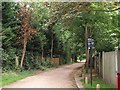
Putney Park Lane, Putney Heath
This lane leads from Putney Heath (road) towards Upper Richmond Road.
It is a public right of way leading past a church and at the back of several houses.
Image: © David Anstiss
Taken: 30 Dec 2012
0.11 miles
3
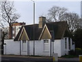
South Lodge, Putney Heath
This house is at the junction of Putney Heath Road and Telegraph Road.
Image: © David Anstiss
Taken: 30 Dec 2012
0.11 miles
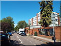
4
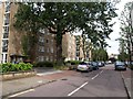
Tildesley Road
A row of flats on the west side of the road, seen from the road along the north side of Putney Heath.
Image: © Derek Harper
Taken: 1 Aug 2009
0.11 miles
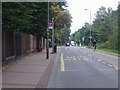
5
Putney Heath
The road running along the north edge of Putney Heath is called Putney Heath.
Image: © Malc McDonald
Taken: 5 Aug 2018
0.12 miles
6
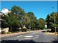
Putney Heath
A mini-roundabout on Putney Heath.
Image: © Malc McDonald
Taken: 5 Aug 2018
0.12 miles
8
Dover Park Drive, Roehampton
Dover Park Drive is a residential road in Roehampton, in the suburbs of south-west London.
Image: © Malc McDonald
Taken: 5 Aug 2018
0.13 miles
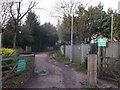
9
Telegraph Road, Putney Heath
This road leads to the Portsmouth Road and Heathview Gardens Estates within the heath.
Image: © David Anstiss
Taken: 30 Dec 2012
0.14 miles
10
Putney Park Lane
"Putney Park Lane may be a remnant of a medieval lane which once provided access to The Pleasance, the site of the Archbishop of Canterbury's Putney Park hunting lodge. The lane was laid out by the early 18th century as a formal tree-lined drive for a house built on the site of the former hunting lodge. It later became the access to a number of grand houses built here including Granard House, Putney Park House and Dover House ... Putney Park Lane is now maintained as public open space by the Borough of Wandsworth" http://www.parkexplorer.org.uk/park_intro.asp?ID=wnd21 . The lane is seen here from its southern end on Putney Heath.
Image: © Derek Harper
Taken: 1 Aug 2009
0.14 miles