IMAGES TAKEN NEAR TO
Laker Place, LONDON, SW15 2HS
Introduction
This page details the photographs taken nearby to Laker Place, SW15 2HS by members of the Geograph project.
The Geograph project started in 2005 with the aim of publishing, organising and preserving representative images for every square kilometre of Great Britain, Ireland and the Isle of Man.

There are currently over 7.5m images from over14,400 individuals and you can help contribute to the project by visiting https://www.geograph.org.uk
Image Map
Images are licensed for reuse under creativecommons.org/licenses/by-sa/2.0
Notes
- Clicking on the map will re-center to the selected point.
- The higher the marker number, the further away the image location is from the centre of the postcode.
Image Listing (50 Images Found)
Images are licensed for reuse under creativecommons.org/licenses/by-sa/2.0
Image
Details
Distance
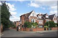
2
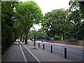
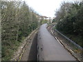
West Hill, Wandsworth
The tree-lined A3 climbs steadily from Wandsworth towards Tibbet's Corner. Behind the wall on the right is Image
Image: © Derek Harper
Taken: 1 Aug 2009
0.08 miles
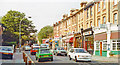
3
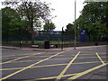
A Putney Junction
An empty box junction on the A3 West Hill and Portinscale Road.
Image: © Anthony Vosper
Taken: 14 Apr 2011
0.10 miles
4
West Hill Putney
Looking towards Wandsworth
Image: © David Howard
Taken: 30 Mar 2008
0.12 miles
5
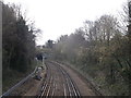
Railway line to Southfields
As seen from Image
This is the District branch tube line to Wimbledon via Southfields. The line has come from Earl's Court via East Putney.
In the background the tube heads into a tunnel to pass under the A3 and Sutherland Grove.
Image: © David Anstiss
Taken: 14 Apr 2013
0.13 miles
6
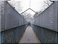
Footbridge near Keswick Road
This bridge leads from Keswick Road towards Clockhouse Place.
It passes over the railway line of the Underground, between East Putney and Southfields on the Wimbledon branch of the District line.
Image: © David Anstiss
Taken: 14 Apr 2013
0.14 miles
7
Railway line to East Putney
As seen from Image
This is the District branch tube line from Wimbledon via Southfields.
Image: © David Anstiss
Taken: 14 Apr 2013
0.14 miles
8
Clockhouse Place, Putney
Photo from path along railway footbridge.
Image: © David Hawgood
Taken: 10 Jun 2023
0.15 miles
9
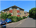
NEW
Clockhouse Place, Putney
A private road.
Image: © Des Blenkinsopp
Taken: 29 Aug 2024
0.17 miles
10
Putney, 1990: westward on Upper Richmond Road
View NW on A205 South Circular Road, just below Messenger Court (on left) where I lived 1990-95; to the right is Schubert Road.
Image: © Ben Brooksbank
Taken: 15 Sep 1990
0.19 miles