IMAGES TAKEN NEAR TO
Skelgill Road, LONDON, SW15 2EF
Introduction
This page details the photographs taken nearby to Skelgill Road, SW15 2EF by members of the Geograph project.
The Geograph project started in 2005 with the aim of publishing, organising and preserving representative images for every square kilometre of Great Britain, Ireland and the Isle of Man.

There are currently over 7.5m images from over14,400 individuals and you can help contribute to the project by visiting https://www.geograph.org.uk
Image Map
Images are licensed for reuse under creativecommons.org/licenses/by-sa/2.0
Notes
- Clicking on the map will re-center to the selected point.
- The higher the marker number, the further away the image location is from the centre of the postcode.
Image Listing (128 Images Found)
Images are licensed for reuse under creativecommons.org/licenses/by-sa/2.0
Image
Details
Distance
1
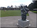
Nexus, Wandsworth Park
On southernmost path of the park (running parallel with Putney Bridge Road).
Part of the Putney Sculpture Trail.
Made by Alan Thornhill.
See http://en.wikipedia.org/wiki/Putney_Sculpture_Trail for more details about the trail.
Image: © David Anstiss
Taken: 14 Apr 2013
0.04 miles
3
Wandsworth Park
The park is situated along the south bank of the River Thames and bordered to the south by Putney Bridge Road. The park is 8 hectares in size and is home to over 350 trees of many different species. It was purchased for £33,000 in 1898 by London County Council, Wandsworth District Board, and by public subscription. An avenue of trees form the northern edge along the river.
Image: © Eirian Evans
Taken: 16 Aug 2013
0.09 miles
6
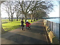
Wandsworth Park
On the south bank of the River Thames. The park was formally opened on Saturday 28 February 1903. A bowling green, pavilion, and tennis courts were added in the 1920s. This pedestrian road is part of The Thames Path.
Image: © Russel Wills
Taken: 8 Dec 2010
0.11 miles
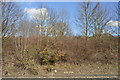
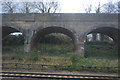
7
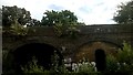
Former railway viaduct, Putney
What is now the southern end of the District Line's Wimbledon branch, south from Putney, was built by the London and South Western Railway, and trains coming off this branch would curve down here to join the main line in from Richmond. The link survived the takeover by London Underground and the junction remained as an option for stock movements until the mid-20th century.
Image: © Christopher Hilton
Taken: 25 Jul 2016
0.11 miles
8
Wandsworth Park
Seen from the walkway beside the River Thames, alongside plane trees. http://web.archive.org/web/20081102051305/http://www.wandsworth.gov.uk/Home/EnvironmentandTransport/Parks/Parkscommons/WandsworthPark.htm or www.wandsworth.gov.uk/download/3414/wandsworth_park .
Image: © Derek Harper
Taken: 15 Oct 2006
0.11 miles
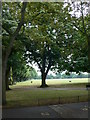
9
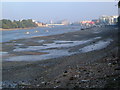
Hurlingham Reach
The River Thames seen from the western edge of Wandsworth Park, with the muddy foreshore exposed at low tide. In the distance are flats on Battersea Reach past Wandsworth Bridge, with the flats at Smugglers Way and Riverside Quarter to the right. Trees on the left mark the grounds of Hurlingham House.
Image: © Derek Harper
Taken: 15 Oct 2006
0.11 miles
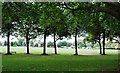
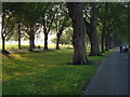
10
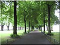
Wandsworth Park
Wandsworth Park is one of two Grade II listed parks in the London Borough of Wandsworth, the other being Battersea Park. The area was formerly in use as allotment gardens until its purchase by the local council in 1898. The park was opened in 1903 and has changed little since. This carriage drive runs parallel to the River Thames, which is over to the left, along the northern side of the park. A combination of dense fresh leaves on the trees and overcast weather made this area particularly gloomy to photograph on the day.
Image: © Nigel Cox
Taken: 28 May 2008
0.11 miles