IMAGES TAKEN NEAR TO
Quill Lane, LONDON, SW15 1PB
Introduction
This page details the photographs taken nearby to Quill Lane, SW15 1PB by members of the Geograph project.
The Geograph project started in 2005 with the aim of publishing, organising and preserving representative images for every square kilometre of Great Britain, Ireland and the Isle of Man.

There are currently over 7.5m images from over14,400 individuals and you can help contribute to the project by visiting https://www.geograph.org.uk
Image Map
Images are licensed for reuse under creativecommons.org/licenses/by-sa/2.0
Notes
- Clicking on the map will re-center to the selected point.
- The higher the marker number, the further away the image location is from the centre of the postcode.
Image Listing (121 Images Found)
Images are licensed for reuse under creativecommons.org/licenses/by-sa/2.0
Image
Details
Distance
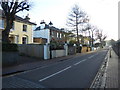
1
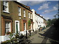
Quill Lane, Putney
Taking a photograph of some of the attractive streets in Putney is difficult because of parked cars. Quill Lane is one of the exceptions as it is too narrow for cars and has been pedestrianised.
Image: © Marathon
Taken: 6 Oct 2010
0.01 miles
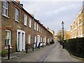
2
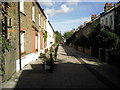
Quill Lane
Parked cars spoil photographs of many an attractive street in Putney. Quill Lane is one of the exceptions as it is clearly too narrow for cars and has therefore been pedestrianised.
Image: © Marathon
Taken: 6 Oct 2010
0.02 miles
4
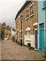
Quill Lane, Putney
A short stretch of pedestrianised road linking Charlwood Road with Cardinal Place, with the curving Quill Terrace on the right.
Image: © Derek Harper
Taken: 7 Feb 2010
0.04 miles
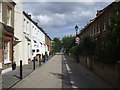
5
Charlwood Road, Putney
Charlwood Road is divided into two parts by Lacy Road. This is the northern part. It appealed to me because most roads in Putney are clogged by cars, which do not add to the view, but Charlwood Road here is too narrow for people to park their cars. On the other side of the road to the right (out of view) is Hotham Primary School - see http://www.geograph.org.uk/photo/2377263
Image: © Marathon
Taken: 28 Dec 2016
0.04 miles
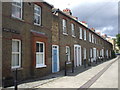
7
Modder Place, Putney
According to the 1901 census, my great-grandparents lived just round the corner in Charlwood Terrace. That little street has been so transformed that the old 'omnibus driver' and his wife would scarcely recognise it - or so I fear. On the other hand, the terrace on the west side of Modder Place cannot have changed all that much in the space of 110 years.
Image: © Stefan Czapski
Taken: 24 Dec 2011
0.05 miles
8
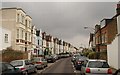
Chevington Road, Putney
The road runs parallel to Image and slightly nearer the river, which perhaps explains why the houses, though still terraced, are a little grander. This is from the junction with Charlwood Road.
Image: © Derek Harper
Taken: 7 Feb 2010
0.05 miles
9
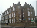
Hotham Primary School
On the corner of Hotham Road to the right and Charlwood Road to the left, Hotham Primary School is another very impressive board school. The notice behind the tree shows that it was founded as Hotham Road Schools.
Image: © Marathon
Taken: 16 Mar 2011
0.07 miles
10
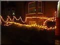
Lit up for Christmas
This house is in Charlwood Road, Putney.
Image: © Marathon
Taken: 23 Dec 2020
0.07 miles