IMAGES TAKEN NEAR TO
Lifford Street, LONDON, SW15 1NY
Introduction
This page details the photographs taken nearby to Lifford Street, SW15 1NY by members of the Geograph project.
The Geograph project started in 2005 with the aim of publishing, organising and preserving representative images for every square kilometre of Great Britain, Ireland and the Isle of Man.

There are currently over 7.5m images from over14,400 individuals and you can help contribute to the project by visiting https://www.geograph.org.uk
Image Map
Images are licensed for reuse under creativecommons.org/licenses/by-sa/2.0
Notes
- Clicking on the map will re-center to the selected point.
- The higher the marker number, the further away the image location is from the centre of the postcode.
Image Listing (197 Images Found)
Images are licensed for reuse under creativecommons.org/licenses/by-sa/2.0
Image
Details
Distance
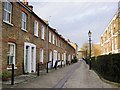
1
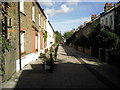
Quill Lane
Parked cars spoil photographs of many an attractive street in Putney. Quill Lane is one of the exceptions as it is clearly too narrow for cars and has therefore been pedestrianised.
Image: © Marathon
Taken: 6 Oct 2010
0.05 miles
2
Quill Lane, Putney
Taking a photograph of some of the attractive streets in Putney is difficult because of parked cars. Quill Lane is one of the exceptions as it is too narrow for cars and has been pedestrianised.
Image: © Marathon
Taken: 6 Oct 2010
0.06 miles
3
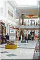
Putney Exchange, interior 1991
View towards the entrance.
Image: © Ben Brooksbank
Taken: 18 Jul 1991
0.08 miles
5
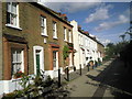
Modder Place, Putney
According to the 1901 census, my great-grandparents lived just round the corner in Charlwood Terrace. That little street has been so transformed that the old 'omnibus driver' and his wife would scarcely recognise it - or so I fear. On the other hand, the terrace on the west side of Modder Place cannot have changed all that much in the space of 110 years.
Image: © Stefan Czapski
Taken: 24 Dec 2011
0.08 miles
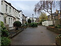
6
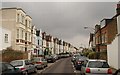
Chevington Road, Putney
The road runs parallel to Image and slightly nearer the river, which perhaps explains why the houses, though still terraced, are a little grander. This is from the junction with Charlwood Road.
Image: © Derek Harper
Taken: 7 Feb 2010
0.08 miles
7
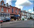
Royal China Restaurant, Chelverton Road, Putney
Image: © PAUL FARMER
Taken: 6 Apr 2013
0.08 miles
8
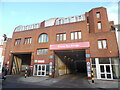
Putney Bus Garage
Located at 10 Chelverton Road SW15 IRH, this bus garage was first used as horse-bus stables in 1888, but then became a motor-bus garage on Thursday 18th July 1912. Rebuilding of this garage took place in 1935/6, while further improvements were carried out in 1985/6. Formerly a London Transport bus garage, it is now one of a few operated by London General Transport Services and has approximately 120 buses based here. Day bus routes operated by this garage are 14, 22, 74, 209, 337, 378, 424, 430 and 533 while bus routes worked through the night are 14, N22 and N74.
Image: © David Hillas
Taken: 19 Jan 2023
0.09 miles
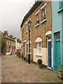
9
Olivette Street, Putney
Taking a photograph of some of the attractive streets in Putney is difficult because of parked cars. The pedestrianised Olivette Street is one of the exceptions.
Image: © Marathon
Taken: 23 Dec 2020
0.09 miles
10
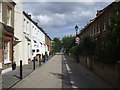
Quill Lane, Putney
A short stretch of pedestrianised road linking Charlwood Road with Cardinal Place, with the curving Quill Terrace on the right.
Image: © Derek Harper
Taken: 7 Feb 2010
0.09 miles