IMAGES TAKEN NEAR TO
Mortlake High Street, LONDON, SW14 8SL
Introduction
This page details the photographs taken nearby to Mortlake High Street, SW14 8SL by members of the Geograph project.
The Geograph project started in 2005 with the aim of publishing, organising and preserving representative images for every square kilometre of Great Britain, Ireland and the Isle of Man.

There are currently over 7.5m images from over14,400 individuals and you can help contribute to the project by visiting https://www.geograph.org.uk
Image Map (Loading...)


Getting Data...Please wait
Leaflet Map data © OpenStreetMap
Images are licensed for reuse under creativecommons.org/licenses/by-sa/2.0
Notes
- Clicking on the map will re-center to the selected point.
- The higher the marker number, the further away the image location is from the centre of the postcode.
Image Listing (356 Images Found)
Images are licensed for reuse under creativecommons.org/licenses/by-sa/2.0
Image
Details
Distance
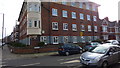
1
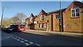
The old electricity works building
Mortlake high street.
Image: © James Emmans
Taken: 17 Apr 2021
0.02 miles
3
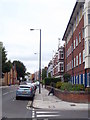
The A3003 Mortlake High Street
The road on the right is Ashleigh Road Image
Image: © Rod Allday
Taken: 25 Jun 2011
0.06 miles
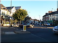
5
Corner of Ashleigh Road with Mortlake High Street
Image: © Richard Cooke
Taken: 11 Mar 2018
0.06 miles
6
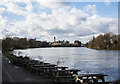
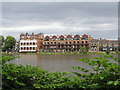
The River Thames
Looking upstream towards the Mortlake Brewery from beside The White Hart public house in Barnes.
Image: © Martin Addison
Taken: 19 Feb 2016
0.07 miles
8

Ashleigh Road SW14
A leasant tree-lined road off Mortlake High Street.
Image: © Rod Allday
Taken: 25 Jun 2011
0.08 miles
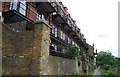
10
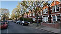
Ashleigh Road - Mortlake
Large Edwardian terrace housing.
Image: © James Emmans
Taken: 17 Apr 2021
0.09 miles