IMAGES TAKEN NEAR TO
Vicarage Road, LONDON, SW14 8RY
Introduction
This page details the photographs taken nearby to Vicarage Road, SW14 8RY by members of the Geograph project.
The Geograph project started in 2005 with the aim of publishing, organising and preserving representative images for every square kilometre of Great Britain, Ireland and the Isle of Man.

There are currently over 7.5m images from over14,400 individuals and you can help contribute to the project by visiting https://www.geograph.org.uk
Image Map (Loading...)


Getting Data...Please wait
Leaflet Map data © OpenStreetMap
Images are licensed for reuse under creativecommons.org/licenses/by-sa/2.0
Notes
- Clicking on the map will re-center to the selected point.
- The higher the marker number, the further away the image location is from the centre of the postcode.
Image Listing (47 Images Found)
Images are licensed for reuse under creativecommons.org/licenses/by-sa/2.0
Image
Details
Distance
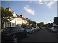
1
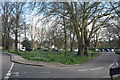
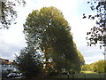
Mortlake: Trees at north end of Palewell Common
Image: © Dr Neil Clifton
Taken: 24 Apr 2013
0.06 miles
5
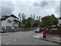
Postbox at the corner of Park Drive and Sunbury Avenue
Image: © Basher Eyre
Taken: 31 May 2017
0.07 miles
6
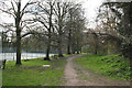
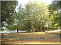
Mortlake: Footpath and trees, Palewell Park
Image: © Dr Neil Clifton
Taken: 24 Apr 2013
0.07 miles
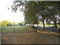
9
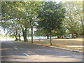
Row of trees on Palewell Common
Along Hertford Road on the left
Image: © David Howard
Taken: 8 Aug 2015
0.08 miles
