IMAGES TAKEN NEAR TO
Richmond Park Road, LONDON, SW14 8LA
Introduction
This page details the photographs taken nearby to Richmond Park Road, SW14 8LA by members of the Geograph project.
The Geograph project started in 2005 with the aim of publishing, organising and preserving representative images for every square kilometre of Great Britain, Ireland and the Isle of Man.

There are currently over 7.5m images from over14,400 individuals and you can help contribute to the project by visiting https://www.geograph.org.uk
Image Map
Images are licensed for reuse under creativecommons.org/licenses/by-sa/2.0
Notes
- Clicking on the map will re-center to the selected point.
- The higher the marker number, the further away the image location is from the centre of the postcode.
Image Listing (57 Images Found)
Images are licensed for reuse under creativecommons.org/licenses/by-sa/2.0
Image
Details
Distance
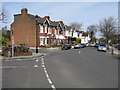
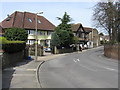
2
Sheen Lane, East Sheen
This is a stretch of the B351 running south from Mortlake to Richmond Park. The junction with Shrewsbury Avenue is ahead. The yellow road markings in the foreground are opposite Tower House School.
Image: © Stephen McKay
Taken: 14 Mar 2019
0.08 miles
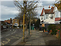
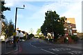
3
Sheen Lane
Looking in the direction of Richmond Park.
Image: © Peter Trimming
Taken: 23 Sep 2017
0.10 miles

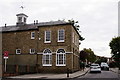
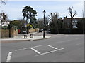
7
A quiet Sheen Lane
Sheen Lane near the junction with Upper Richmond Road West. The road was closed for the Ride 100 cycle event.
Image: © DS Pugh
Taken: 2 Aug 2015
0.13 miles
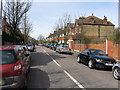
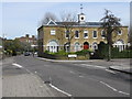
10
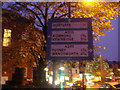
Pre-Worboys sign East Sheen
Sheen Lane junction Upper Richmond Road. Now replaced with current type.
Image: © David Howard
Taken: 10 Nov 2008
0.14 miles