IMAGES TAKEN NEAR TO
Kingsway, LONDON, SW14 7HS
Introduction
This page details the photographs taken nearby to Kingsway, SW14 7HS by members of the Geograph project.
The Geograph project started in 2005 with the aim of publishing, organising and preserving representative images for every square kilometre of Great Britain, Ireland and the Isle of Man.

There are currently over 7.5m images from over14,400 individuals and you can help contribute to the project by visiting https://www.geograph.org.uk
Image Map
Images are licensed for reuse under creativecommons.org/licenses/by-sa/2.0
Notes
- Clicking on the map will re-center to the selected point.
- The higher the marker number, the further away the image location is from the centre of the postcode.
Image Listing (56 Images Found)
Images are licensed for reuse under creativecommons.org/licenses/by-sa/2.0
Image
Details
Distance
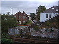
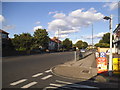
1
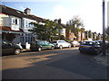
Kingsway at the junction of Shalstone Road
Image: © David Howard
Taken: 2 Aug 2014
0.04 miles
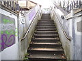
2
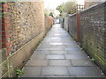
Central School Path, Mortlake
From Kingsway to The Byeway and along the railway line beyond.
Image: © David Howard
Taken: 26 Jan 2014
0.04 miles
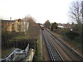
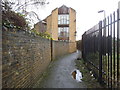
4

Railway line between North and South Worple Way
Taken from one of the footbridges
Image: © David Howard
Taken: 7 Sep 2009
0.05 miles
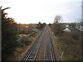
5
Railway between South and North Worple Way, Mortlake
Image: © David Howard
Taken: 7 Sep 2009
0.05 miles
9
Lower Richmond Road at the junction of Kingsway
Image: © David Howard
Taken: 2 Aug 2014
0.05 miles