IMAGES TAKEN NEAR TO
Scarth Road, LONDON, SW13 0ND
Introduction
This page details the photographs taken nearby to Scarth Road, SW13 0ND by members of the Geograph project.
The Geograph project started in 2005 with the aim of publishing, organising and preserving representative images for every square kilometre of Great Britain, Ireland and the Isle of Man.

There are currently over 7.5m images from over14,400 individuals and you can help contribute to the project by visiting https://www.geograph.org.uk
Image Map (Loading...)


Getting Data...Please wait
Leaflet Map data © OpenStreetMap
Images are licensed for reuse under creativecommons.org/licenses/by-sa/2.0
Notes
- Clicking on the map will re-center to the selected point.
- The higher the marker number, the further away the image location is from the centre of the postcode.
Image Listing (134 Images Found)
Images are licensed for reuse under creativecommons.org/licenses/by-sa/2.0
Image
Details
Distance
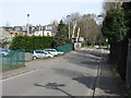
1
Beverley Gardens
Beverley Gardens junction with Brook Gardens
Image: © Shaun Ferguson
Taken: 18 Dec 2008
0.03 miles
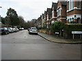
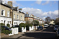
2
Houses in Scarth Road, Barnes
Photographed from Vine Road.
Image: © Peter Trimming
Taken: 17 May 2009
0.04 miles
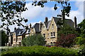
4
Scarth Road, Barnes
On the edge of the common
Image: © David Howard
Taken: 13 Apr 2015
0.05 miles
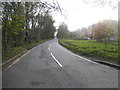
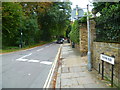
5
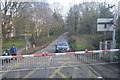
Vine Road level crossing (Hounslow Loop)
Taken from the other level crossing which protects the main line to Richmond.
Image: © Peter Whatley
Taken: 6 Apr 2010
0.05 miles
6
Looking east along Station Road from the junction with Mill Hill Road
Image: © Shazz
Taken: 23 Sep 2013
0.06 miles
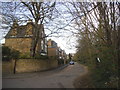
7
Beverley Road
Seen from the corner of Beverley Gardens - looking towards the B349, Station Road.
Image: © Martin Addison
Taken: 19 Feb 2016
0.06 miles
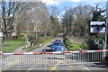
10
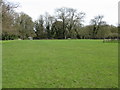
Barnes Common, looking northeast
Rather muddy after recent rainfall.
Image: © Peter Whatley
Taken: 6 Apr 2010
0.06 miles