IMAGES TAKEN NEAR TO
Station Road, LONDON, SW13 0LP
Introduction
This page details the photographs taken nearby to Station Road, SW13 0LP by members of the Geograph project.
The Geograph project started in 2005 with the aim of publishing, organising and preserving representative images for every square kilometre of Great Britain, Ireland and the Isle of Man.

There are currently over 7.5m images from over14,400 individuals and you can help contribute to the project by visiting https://www.geograph.org.uk
Image Map
Images are licensed for reuse under creativecommons.org/licenses/by-sa/2.0
Notes
- Clicking on the map will re-center to the selected point.
- The higher the marker number, the further away the image location is from the centre of the postcode.
Image Listing (139 Images Found)
Images are licensed for reuse under creativecommons.org/licenses/by-sa/2.0
Image
Details
Distance
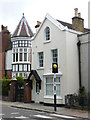
1
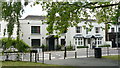
Houses in Station Road, Barnes
Two very attractive houses, photographed from just inside Barnes Green park.
Image: © Peter Trimming
Taken: 17 May 2009
0.03 miles
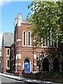
3
Houses in Station Road, Barnes
Quite a contrast in styles.
Image: © Peter Trimming
Taken: 17 May 2009
0.05 miles
5
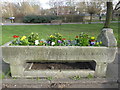
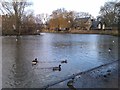
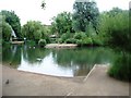
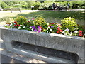
Former horse drinking trough at Barnes Pond
The Metropolitan Drinking Fountain and Cattle Trough Association was set up in London by Samuel Gurney, an MP and philanthropist, and Edward Thomas Wakefield, a barrister, in 1859 to provide free drinking water. Originally called the Metropolitan Free Drinking Fountain Association it changed its name to include cattle troughs in 1867, to also support animal welfare. It must have been difficult to get such a long name onto their drinking troughs. The trough below must have been for dogs.
In this photograph, Barnes Pond is in the background. The area around Barnes Pond is carefully brightened with wildflower areas and other plantings as seen here. Another example of a former horse trough can be seen at https://www.geograph.org.uk/photo/2586889
Image: © Marathon
Taken: 5 Feb 2020
0.06 miles
6
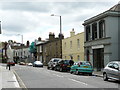
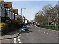
Station Road, Barnes
A variety of buildings, mostly Victorian, in this view which is taken from the Barnes end of Station Road.
Image: © Peter Trimming
Taken: 17 May 2009
0.06 miles
7
Former horse drinking trough near Barnes Pond
The Metropolitan Drinking Fountain and Cattle Trough Association was set up in London by Samuel Gurney, an MP and philanthropist, and Edward Thomas Wakefield, a barrister, in 1859 to provide free drinking water. Originally called the Metropolitan Free Drinking Fountain Association it changed its name to include cattle troughs in 1867, to also support animal welfare. It must have been difficult to get such a long name onto their drinking troughs. The trough below must have been for dogs.
In this photograph, Barnes Pond is in the background. The area around Barnes Pond is carefully brightened with wildflower areas and other plantings as seen here. Another example of a former horse trough can be seen at https://www.geograph.org.uk/photo/2586889
Image: © Marathon
Taken: 24 Jun 2020
0.06 miles
8
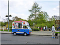
Superscoop on Barnes Green
The vehicle is based on a Bedford Rascal.
Image: © Robin Webster
Taken: 14 Apr 2012
0.07 miles