IMAGES TAKEN NEAR TO
Westwood Road, LONDON, SW13 0LA
Introduction
This page details the photographs taken nearby to Westwood Road, SW13 0LA by members of the Geograph project.
The Geograph project started in 2005 with the aim of publishing, organising and preserving representative images for every square kilometre of Great Britain, Ireland and the Isle of Man.

There are currently over 7.5m images from over14,400 individuals and you can help contribute to the project by visiting https://www.geograph.org.uk
Image Map
Images are licensed for reuse under creativecommons.org/licenses/by-sa/2.0
Notes
- Clicking on the map will re-center to the selected point.
- The higher the marker number, the further away the image location is from the centre of the postcode.
Image Listing (91 Images Found)
Images are licensed for reuse under creativecommons.org/licenses/by-sa/2.0
Image
Details
Distance
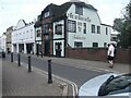
1
Priest's Bridge, Barnes
Looking towards Upper Richmond Road
Image: © David Howard
Taken: 18 Oct 2014
0.08 miles
2

Priest's Bridge, Barnes
The bridge goes over Beverley Brook just ahead by the pub
Image: © David Howard
Taken: 18 Oct 2014
0.09 miles
3

Beverley Brook from Priest's Bridge
The Halfway House pub is on the left
Image: © David Howard
Taken: 18 Oct 2014
0.09 miles
5
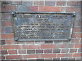
Old sign on Priest's Bridge, Barnes
There are a number of these in SW London but not elsewhere.
Image: © David Howard
Taken: 18 Oct 2014
0.10 miles
6

Upper Richmond Road
Traffic lights at the junction with Vine Road.
Image: © Alan Hughes
Taken: 4 Nov 2019
0.10 miles
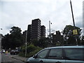
7
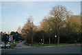
Barnes Common
Seen across Upper Richmond Road.
Image: © Peter Trimming
Taken: 27 Dec 2018
0.10 miles
8
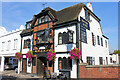
Halfway House
Public House, Priests Bridge in Barnes.
Image: © Wayland Smith
Taken: 1 Oct 2011
0.10 miles