IMAGES TAKEN NEAR TO
Yukon Road, LONDON, SW12 9PZ
Introduction
This page details the photographs taken nearby to Yukon Road, SW12 9PZ by members of the Geograph project.
The Geograph project started in 2005 with the aim of publishing, organising and preserving representative images for every square kilometre of Great Britain, Ireland and the Isle of Man.

There are currently over 7.5m images from over14,400 individuals and you can help contribute to the project by visiting https://www.geograph.org.uk
Image Map
Images are licensed for reuse under creativecommons.org/licenses/by-sa/2.0
Notes
- Clicking on the map will re-center to the selected point.
- The higher the marker number, the further away the image location is from the centre of the postcode.
Image Listing (145 Images Found)
Images are licensed for reuse under creativecommons.org/licenses/by-sa/2.0
Image
Details
Distance
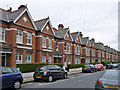
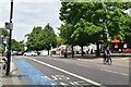
2
Yukon Road
Junction on the right is Beira Road
Image: © PAUL FARMER
Taken: 24 May 2009
0.05 miles
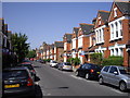
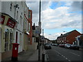
3
Dagnan Road
At the junction with Beira Street.
Image: © James Emmans
Taken: 8 May 2022
0.06 miles
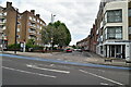
6
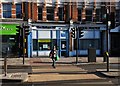
The Balham Hill Medical Centre
On Balham High Road
Image: © Neil Theasby
Taken: 11 Dec 2016
0.08 miles
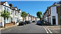
8
Cathles Road SW12
At the corner of Balham Hill.
Image: © Danny P Robinson
Taken: 1 Aug 2006
0.09 miles
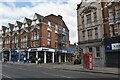
10
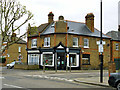
Corner shops, Cavendish Road
This block is wedged between Yukon and Dagnan Roads. Both corners were formerly shops, but that on the left has been converted into a house. That on the right remains a retail premises, trading in carpets and possibly other interior decorations.
Image: © Robin Webster
Taken: 6 May 2012
0.10 miles