IMAGES TAKEN NEAR TO
Brierley Road, LONDON, SW12 9LY
Introduction
This page details the photographs taken nearby to Brierley Road, SW12 9LY by members of the Geograph project.
The Geograph project started in 2005 with the aim of publishing, organising and preserving representative images for every square kilometre of Great Britain, Ireland and the Isle of Man.

There are currently over 7.5m images from over14,400 individuals and you can help contribute to the project by visiting https://www.geograph.org.uk
Image Map
Images are licensed for reuse under creativecommons.org/licenses/by-sa/2.0
Notes
- Clicking on the map will re-center to the selected point.
- The higher the marker number, the further away the image location is from the centre of the postcode.
Image Listing (93 Images Found)
Images are licensed for reuse under creativecommons.org/licenses/by-sa/2.0
Image
Details
Distance
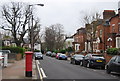
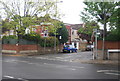
4
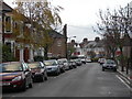
Culverden Road, SW12
Looking towards Byrne Road.
Image: © Danny P Robinson
Taken: 26 Nov 2006
0.04 miles
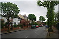
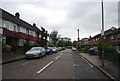
5
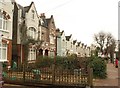
Houses on Fontenoy Road
These distinctively-fronted gabled house fronts are opposite the houses shown in Image, and the postbox is shown in Image
Image: © Derek Harper
Taken: 13 Jan 2011
0.05 miles