IMAGES TAKEN NEAR TO
Balham High Road, LONDON, SW12 9AY
Introduction
This page details the photographs taken nearby to Balham High Road, SW12 9AY by members of the Geograph project.
The Geograph project started in 2005 with the aim of publishing, organising and preserving representative images for every square kilometre of Great Britain, Ireland and the Isle of Man.

There are currently over 7.5m images from over14,400 individuals and you can help contribute to the project by visiting https://www.geograph.org.uk
Image Map
Images are licensed for reuse under creativecommons.org/licenses/by-sa/2.0
Notes
- Clicking on the map will re-center to the selected point.
- The higher the marker number, the further away the image location is from the centre of the postcode.
Image Listing (223 Images Found)
Images are licensed for reuse under creativecommons.org/licenses/by-sa/2.0
Image
Details
Distance
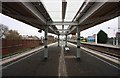
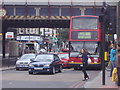
3
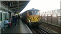
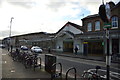
Works train passing through Balham station
Two class 73 electro-diesel locomotives, operating under diesel power, haul a train of ballast southbound.
Image: © Christopher Hilton
Taken: 26 Sep 2016
0.01 miles
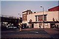
6
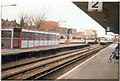
Balham Station
Gatwick Express passing through
Image: © Ron Hann
Taken: Unknown
0.02 miles
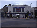
9
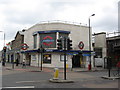
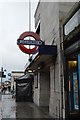
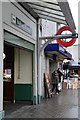
Balham Underground Station
Balham is located on the Northern Line between Clapham South and Tooting Bec stations. It has entrances on the east and west sides of Balham High Road linked by a pedestrian subway. The surface buildings were designed by the architect Charles Holden. The station opened on 6 December 1926. During the Second World War, Balham was one of many deep tube stations designated for use as a civilian air raid shelter. At 20:02 on 14 October, 1940, a 1400kg semi-armour piercing fragmentation bomb fell on the road above the northern end of the platform tunnels, causing a large crater into which a bus then crashed. The northbound platform tunnel partially collapsed and was filled with earth and water from the fractured water mains and sewers above, which also flowed through the cross-passages into the southbound platform tunnel, with the flooding and debris reaching to within 100 yards of Clapham South. Sixty-five civilians in the station were killed, according to the Commonwealth War Graves Commission (CWGC). http://wapedia.mobi/en/Balham_tube_station
Image: © Richard Rogerson
Taken: 5 Nov 2009
0.02 miles