IMAGES TAKEN NEAR TO
Granard Road, LONDON, SW12 8UL
Introduction
This page details the photographs taken nearby to Granard Road, SW12 8UL by members of the Geograph project.
The Geograph project started in 2005 with the aim of publishing, organising and preserving representative images for every square kilometre of Great Britain, Ireland and the Isle of Man.

There are currently over 7.5m images from over14,400 individuals and you can help contribute to the project by visiting https://www.geograph.org.uk
Image Map
Images are licensed for reuse under creativecommons.org/licenses/by-sa/2.0
Notes
- Clicking on the map will re-center to the selected point.
- The higher the marker number, the further away the image location is from the centre of the postcode.
Image Listing (112 Images Found)
Images are licensed for reuse under creativecommons.org/licenses/by-sa/2.0
Image
Details
Distance
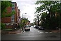
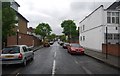
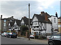
4
Road junction on the edge of Wandsworth Common
Image: © N Chadwick
Taken: 8 May 2010
0.07 miles
5
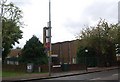
Church of Jesus Christ of Latter Day Saints, Nightingale Lane
Image: © N Chadwick
Taken: 8 May 2010
0.07 miles
6
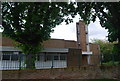
Church of Jesus Christ of Latter Day Saints, Nightingale Lane
Image: © N Chadwick
Taken: 8 May 2010
0.07 miles
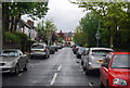
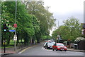
10
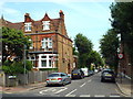
Morella Road, near Wandsworth Common
Morella Road is a residential street in the suburbs of south London.
Image: © Malc McDonald
Taken: 1 Jul 2018
0.09 miles