IMAGES TAKEN NEAR TO
Airedale Road, LONDON, SW12 8SF
Introduction
This page details the photographs taken nearby to Airedale Road, SW12 8SF by members of the Geograph project.
The Geograph project started in 2005 with the aim of publishing, organising and preserving representative images for every square kilometre of Great Britain, Ireland and the Isle of Man.

There are currently over 7.5m images from over14,400 individuals and you can help contribute to the project by visiting https://www.geograph.org.uk
Image Map
Images are licensed for reuse under creativecommons.org/licenses/by-sa/2.0
Notes
- Clicking on the map will re-center to the selected point.
- The higher the marker number, the further away the image location is from the centre of the postcode.
Image Listing (121 Images Found)
Images are licensed for reuse under creativecommons.org/licenses/by-sa/2.0
Image
Details
Distance
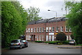
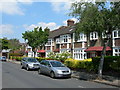
1
Airedale Road, Balham
Only the first couple of houses in the terrace are in square; it then crosses into Image
Image: © Derek Harper
Taken: 8 Feb 2015
0.04 miles
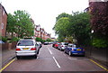
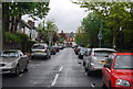
2
Birchlands Avenue SW12
A quiet suburban road in Balham, just off Bellevue Road.
Image: © Danny P Robinson
Taken: 16 Jun 2006
0.05 miles
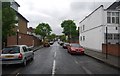
5
Path between Jaggard Way and Wexford Road, Wandsworth Common
Image: © David Howard
Taken: 17 Aug 2008
0.11 miles
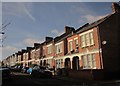
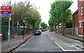
6
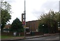
Church of Jesus Christ of Latter Day Saints, Nightingale Lane
Image: © N Chadwick
Taken: 8 May 2010
0.11 miles
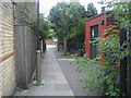
7
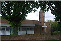
Church of Jesus Christ of Latter Day Saints, Nightingale Lane
Image: © N Chadwick
Taken: 8 May 2010
0.12 miles