IMAGES TAKEN NEAR TO
Endlesham Road, LONDON, SW12 8JX
Introduction
This page details the photographs taken nearby to Endlesham Road, SW12 8JX by members of the Geograph project.
The Geograph project started in 2005 with the aim of publishing, organising and preserving representative images for every square kilometre of Great Britain, Ireland and the Isle of Man.

There are currently over 7.5m images from over14,400 individuals and you can help contribute to the project by visiting https://www.geograph.org.uk
Image Map
Images are licensed for reuse under creativecommons.org/licenses/by-sa/2.0
Notes
- Clicking on the map will re-center to the selected point.
- The higher the marker number, the further away the image location is from the centre of the postcode.
Image Listing (68 Images Found)
Images are licensed for reuse under creativecommons.org/licenses/by-sa/2.0
Image
Details
Distance
1
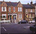
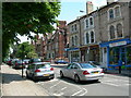
Endlesham Road
View eastwards from Western Lane towards the typical Victorian houses on Endlesham Road. This area is now much more up-market than when I used to live there in the 1970s.
Image: © Trevor Rickard
Taken: Unknown
0.02 miles
2
Houses on Ramsden Road, Balham
The house on the corner with Temperley Road was extended by project architects Matthew Heywood Limited.
Image: © Derek Harper
Taken: 8 Feb 2015
0.07 miles
3
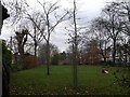
Nightingale Square, Balham
This small private garden space is used by the local residents of this square.
I don't think they left a traffic cone on the grass!
Image: © David Anstiss
Taken: 9 Dec 2012
0.07 miles
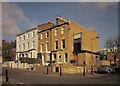
4
Building on Corner of Endlesham Road SW12
These are absolutely magnificent old houses. I do not know if they were ever once occupied by only one household. Some of the windows on the ground floor look as though they were once doorways.
Image: © Danny P Robinson
Taken: 16 Jun 2006
0.09 miles
5
Nightingale Lane SW12
At the corner of Endlesham Road. Looking towards Clapham South tube station.
Image: © Danny P Robinson
Taken: 16 Jun 2006
0.09 miles
6
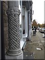
Detail of facade of the shops in Nightingale Lane
Between each shop building there are these elaborate pillars
Image: © David Smith
Taken: 17 Nov 2016
0.09 miles
7
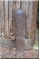
Old Boundary Marker by the B229, Nightingale Lane, Battersea
Parish Boundary Marker by the B229, in parish of Battersea (Wandsworth District), Nightingale Lane SW12, at corner with Ramsden Road, against fence.
Surveyed
Milestone Society National ID: SY_BATT17pb
Image: © Milestone Society
Taken: Unknown
0.10 miles
8
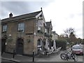
The Nightingale in Nightingale Lane
The inn has a very shallow space for outdoor customers; it has a plaque on the gable reading: The Nightingale Thomas Wallis 1853
Image: © David Smith
Taken: 17 Nov 2016
0.10 miles
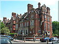
9
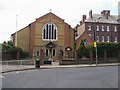
Holy Ghost Church
Holy Ghost Church Nightingale Square
Image: © Shaun Ferguson
Taken: 10 Jul 2009
0.11 miles
10
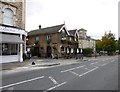
Balham, The Nightingale
Community pub at the corner of Nightingale Lane and Western Lane; curving central bar with drinking area front, left, right, and larger eating area at back; darts, games machine; good Victorian glassware. Cask ales on offer at my visit: Adnams Topaz Gold, Horns Wheat, Surrey Hills Shere Drop, Youngs Bitter & Special. A plaque dates the building to 1853. For some customer comments, see http://www.beerintheevening.com/pubs/s/53/5309/Nightingale/Balham
Image: © Mike Faherty
Taken: 27 Oct 2012
0.11 miles