IMAGES TAKEN NEAR TO
Sarsfeld Road, LONDON, SW12 8HT
Introduction
This page details the photographs taken nearby to Sarsfeld Road, SW12 8HT by members of the Geograph project.
The Geograph project started in 2005 with the aim of publishing, organising and preserving representative images for every square kilometre of Great Britain, Ireland and the Isle of Man.

There are currently over 7.5m images from over14,400 individuals and you can help contribute to the project by visiting https://www.geograph.org.uk
Image Map
Images are licensed for reuse under creativecommons.org/licenses/by-sa/2.0
Notes
- Clicking on the map will re-center to the selected point.
- The higher the marker number, the further away the image location is from the centre of the postcode.
Image Listing (124 Images Found)
Images are licensed for reuse under creativecommons.org/licenses/by-sa/2.0
Image
Details
Distance
2
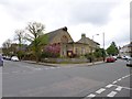
Balham, St. Jude's
Free Church of England church, at the corner of Heslop and Sarsfeld Roads: http://www.fcofesd.org.uk/history.html
Image: © Mike Faherty
Taken: 27 Apr 2013
0.04 miles
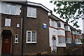
7
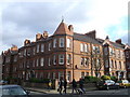
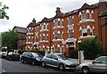
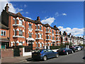
Boundaries Mansions, Balham
Large red-brick block of housing on Boundaries Road beside Tunley Road (on the right).
Image: © David Anstiss
Taken: 9 Dec 2012
0.07 miles
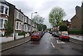
8
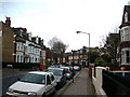
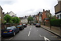
Balham Park Road, SW12 (1)
Near Heslop Road.
Image: © Danny P Robinson
Taken: 26 Nov 2006
0.07 miles
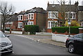
9
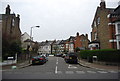
Balham Park Mansions
The Capital Ring path goes past here, a typical street on the walk between Wandsworth and Tooting Commons.
Image: © Des Blenkinsopp
Taken: 31 Mar 2015
0.07 miles