IMAGES TAKEN NEAR TO
Boundaries Road, LONDON, SW12 8HG
Introduction
This page details the photographs taken nearby to Boundaries Road, SW12 8HG by members of the Geograph project.
The Geograph project started in 2005 with the aim of publishing, organising and preserving representative images for every square kilometre of Great Britain, Ireland and the Isle of Man.

There are currently over 7.5m images from over14,400 individuals and you can help contribute to the project by visiting https://www.geograph.org.uk
Image Map
Images are licensed for reuse under creativecommons.org/licenses/by-sa/2.0
Notes
- Clicking on the map will re-center to the selected point.
- The higher the marker number, the further away the image location is from the centre of the postcode.
Image Listing (58 Images Found)
Images are licensed for reuse under creativecommons.org/licenses/by-sa/2.0
Image
Details
Distance
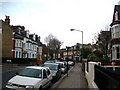
1
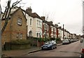
Wontner Road
A street of decorated terraced houses, seen from the junction with Upper Tooting Park.
Image: © Derek Harper
Taken: 13 Jan 2011
0.09 miles
2
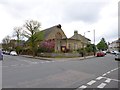
Balham, St. Jude's
Free Church of England church, at the corner of Heslop and Sarsfeld Roads: http://www.fcofesd.org.uk/history.html
Image: © Mike Faherty
Taken: 27 Apr 2013
0.12 miles
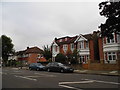
4
Boundaries Mansions, Balham
Large red-brick block of housing on Boundaries Road beside Tunley Road (on the right).
Image: © David Anstiss
Taken: 9 Dec 2012
0.13 miles
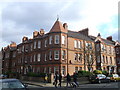
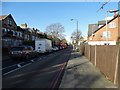
5
Balham Park Road, SW12 (1)
Near Heslop Road.
Image: © Danny P Robinson
Taken: 26 Nov 2006
0.14 miles
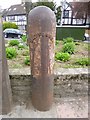
6
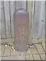
Old Boundary Marker by Upper Tooting Park, Battersea parish
Parish Boundary Marker by the UC road, in parish of Battersea (Wandsworth District), Upper Tooting Park SW17, 20m East of the junction with St James Drive, against fence, North side of road.
Inscription reads:-
BATTERSEA
1866
Surveyed
Milestone Society National ID: SY_BATT23pb
Image: © Milestone Society
Taken: Unknown
0.14 miles
7
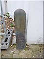
Old Boundary Marker by Upper Tooting Park, Battersea parish
Parish Boundary Marker by the UC road, in parish of Battersea (Wandsworth District), Upper Tooting Park SW17, against corner of wall by garages.
N.B. Garages have been redeveloped and Boundary Marker appears to have been removed.
Inscription reads:-
BATTERSEA
1874(?)
Surveyed
Milestone Society National ID: SY_BATT24pb
Image: © Milestone Society
Taken: Unknown
0.15 miles
9
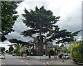
Cedar, St James's Drive
In the front garden of a house at the corner of Brodrick Road. Splendid as it is, it must steal a lot of light. Not that one could miss it when viewing the house.
Image: © Stephen Richards
Taken: 14 Aug 2011
0.15 miles
10
Old Boundary Marker by the A214, Trinity Road, Battersea parish
Parish Boundary Marker by the A214, in parish of Battersea (Wandsworth District), Trinity Road SW17, at junction with St James's Drive against flower bed wall. Adjacent to SY_WAND01pb Image
Inscription reads:-
BATTERSEA
Surveyed
Milestone Society National ID: SY_BATT25pb
Image: © Milestone Society
Taken: Unknown
0.15 miles